
IMPORTANT NOTICE!
Activities and vehicle modifications appearing, described, recommended, or linked to on this web site may be potentially dangerous.
We do not endorse any such activity for others or recommend it to any particular person.
These are simply the experiences and opinions of the writers.
If you choose to engage in these activities it is by your own free will and at your own risk.
Any and all modifications will likely cause a vehicle to behave differently than stock - some modifications may significantly increase your risk for an accident
or equipment failure when driving the vehicle or be dangerous in some driving situations.
Use common sense when engaging in any activity or making any modifications.
Do not take unwise risks, consult a certified professional if you are not sure of something, if you are uncomfortable with your mechanical ability, if you don't
have the experience to do a project, if you have not received proper training and education for the job you are thinking about doing, or if you do not have the proper tools, equipment or safety devices to do the job you are considering.
The owners, operators, members (or any associated parties) of the JEEPEXPEDITIONS.ORG web site and the writers / authors of the content contained within this web
site are not liable or financially responsible for any damages including -- but not limited to -- emotional, physical, or financial damages incurred during or after
the use of this web site or any content contain within.
|

EQUIPMENT REVIEWS:
DELORME EARTHMATE GPS PN-40
As seen in JPFreek Adventure Magazine, Winter 2008 - Review by Mike Fissel - Contributing Editor
Here Is What They Say About It:
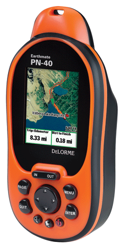
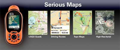
The Earthmate PN-40 is a high-sensitivity, high-performance, bright-color-screen handheld GPS that offers an unrivaled selection of display options
including up-to-date DeLorme Topo USA topographic maps, color aerial imagery, USGS 7.5-min. topographic quad maps, and NOAA nautical charts.
- New--Blazing-fast, high-sensitivity 32-channel STMicroelectronics Cartesio chipset
- New--Dual-core processor for instantaneous map and satellite imagery redraws, even with large aerial imagery files and multiple maps layers
- 360¡ raster rotation sets the PN-40 apart from other common GPS handhelds. With 360¡ rotation road, building, and other images really are on your
left or right as you look at the map and walk, bike or drive
- New--3-axis electronic compass with included accelorometer performs when held in any positionÑwhile in motion or standing still
- New--Sensitive barometric altimeter for reliably accurate altitude readings
- WAAS-enabled for accuracy within 3 meters
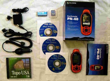
- New--Now supports SDHC high-capacity SD cards (up to 32 GB) for fast and direct map transfer from the included maps discs
Here Is What WE Say About It
Jeep Expeditions was lucky enough to get one of the first PN-40 units available and here is out story in plain talk,
for anyone who depends on GPS for off-highway, back country excursions and/or daily use in the city.
First off, the PN-40 has a very bright color screen that is readable in the brightest sunlight, much
like the PN-20 (also reviewed in this section). Secondly, is that Delorme uses the same high resolution
Topo 7 software that you use on your home PC or laptop. Unlike the "competition", you can also download
USGS Topo Quads and high resolution aerial images by purchasing a $29.95 subscription. How cool is that?
Plus, you can switch from map to map, look at your position from the Topo 7 software view, switch to the Topo Quads,
then switch to the high resolution aerial images. The new PN-40 acquires a 3D fix much faster than many
other units due to the new 32 bit GPS chipset, but that's not all.
The PN-40 takes SD cards up to 32GB to store all the maps you will ever need on any trip. Compare that to the
2GB for the PN-20 and the 2 to 4 gigs for most of the other units currently on the market. In addition,
it has 512mb of built-in flash memory over and above the memory dedicated to the base maps. Add to this a three
axis electronic compass and the barometric altimeter and the PN-40 is a clear winner. It can store 50 routes
10 tracks with 10,000 points per track and 1,000 separate waypoints!
 The included Delorme Topo 7 software has the same street level info as the Delorme Street Atlas software
so your PN-40 will always let you know where you are without having to switch back and forth from Topo to Streets.
Try that with any other Topo software product on the market today. To give you and example of just how much more detailed the maps of
Topo 7 are than the maps available for your Garmin, you can put half the country on a 1GB SD card for your Garmin GPS. For the same 1 GB
of memory, you can squeeze in all of Arizona with little room left over. While that might be good for a trip down the interstate from sea to
shining sea, it won't satisfy your needs for GPS in the back country. The Delorme software is so detailed that a 32GB card will hold only
about 80% of the US. Do the math and you're decision to buy Delore will be very easy.
The included Delorme Topo 7 software has the same street level info as the Delorme Street Atlas software
so your PN-40 will always let you know where you are without having to switch back and forth from Topo to Streets.
Try that with any other Topo software product on the market today. To give you and example of just how much more detailed the maps of
Topo 7 are than the maps available for your Garmin, you can put half the country on a 1GB SD card for your Garmin GPS. For the same 1 GB
of memory, you can squeeze in all of Arizona with little room left over. While that might be good for a trip down the interstate from sea to
shining sea, it won't satisfy your needs for GPS in the back country. The Delorme software is so detailed that a 32GB card will hold only
about 80% of the US. Do the math and you're decision to buy Delore will be very easy.
Did I mention that it was easy to use? I took my PN40 out of the box, loaded the Topo 7 software onto a 32GB SDHC card and
in less than an hour (I don't read manuals) I was an "expert" in how to use it. With the Topo 7 software loaded onto your home PC
or laptop, you can plan out a trip or review past trips. It's easy to upload and download from the PN40 to your PC and from you PC to
the PN40.
Compare the PN40 with the Garmin Colorado series at $600. The Colorado seems to be closest in features from what I could tell but even the color ETrex at $249
cant stand up to a head to head match with the PN-40 in my opinion. It's clearly a better unit for the money based on it's highly detailed maps, the availability
to download USGS 1:24,000 Topo Quad and high resolution aerial images plus there is no extra expense to buy routable street maps with the included Topo 7 software.
At a price point of under $300, Delorme wins by TKO hands down!
 A minor consideration for some, you can share you tracks and waypoints with your buddies Garmin via a GPX download, but they still dont have the
detail and map choices that you'll have with the PN-40.
A minor consideration for some, you can share you tracks and waypoints with your buddies Garmin via a GPX download, but they still dont have the
detail and map choices that you'll have with the PN-40.
I might also mention that the basemaps for the DeLorme unit are for the entire planet! Something that Garmin does not offer for the occasional world traveler.
Power and speed, features, ease of use and Topo 7 software make the new PN-40 the leader of the GPS pack by leap an bounds!
Available online at DeLorme.com and many fine stores nationwide for under $300 depending on accessories.
----------------------------------------------------------------------------------------------------------------------------------------
|
 |
Want to have YOUR Product Reviewed Here?
If you have a quality product that can be used by the off-road pubic we would be glad to test it, do a fair write up about it
and make an honest recommendation about it.
Products that we feel are useful to off-road travel whether it be Jeep related or camping related will not only be posted on our website but we will submit them
to one of several magazines for more possible exposure.
Email info@jeepexpeditions.org with detailed information about your product and your interest in working with
our organization.
------------------------------------------------------------------------------------------------------------------------------------------------------
*The opinions expressed in this product review are the opinions of the writer and are based on the writers tastes and preferences. The writer
may have and in most cases invited other people to participate in this review. Despite the review (favorable/unfavorable)
you are encouraged to try out any product that you might be interested in.
**Copyrighted images & trademarks for products/items appearing on this website and/or portrayed and reviewed here
are the property of their respective owners
and are used within for informative and identification purposes only.
|
|
Jeep Expeditions is the PREMIERE Jeep Exclusive Expedition/Overland Adventure CLUB Anywhere!
Jeep Expeditions is a non-profit corporation registered in the State of Arizona.
The state recognizes us as a fraternal
organization, we prefer to say we are a club. Our members and volunteers are dedicated to the exploration of
this great land for the educational value, historical value, scenic beauty, the geology, paleontology, the camaraderie of people
who share the same interests and to escape the confines of civilization if only for a few days. Our organization and members adhere to the
standards of "Tread Lightly" and "Leave No Trace".
Jeep Expedition Members enjoy adventures that vary in length from one day, a weekend, long weekend, week long, two weeks and like our Arctic
Expedition in 2011, a full month. Don't worry, most of our trips are one day and two day trips. We are Family Friendly and we have
a number of members who bring their friendly "Jeep Dogs".
Copyright © 2006 - 2023 Jeep Expeditions, Inc. All Rights Reserved.
Jeep Expeditions Group, Jeep Expeditions, Inc., Jeep Expeditions, JeepExpeditions USA, JeepExpeditions.org. JeepExpeditions.club,
JeepExpeditions.com and other names we use along with domain names owned by Jeep Expeditions, Inc are all Copyrights & Trademarks held by
Jeep Expeditions, Inc. d/b/a "Jeep Expeditions" We also own Copyrights and Trademarks to our logo, Trip Decals and other variations of such as shown
on this website, our Facebook Page, Twitter and Instagram accounts.
Jeep Wrangler, Jeep Wrangler Unlimited, Jeep Wagoneer, Jeep Commander, Jeep Grand Cherokee, Jeep Liberty, Jeep Cherokee, Jeep Gladiator,
Jeep Scrambler, Jeep CJ, Rubicon, Renegade, Laredo, Overland, SRT-8, HEMI, Rock-Trac, Command-Trac, Selec-Trac, Quadra-Trac, Quadra-Trac II,
Quadra-Drive, Quadra-Drive II, SmartBeam, Jeep, the Jeep logo, and the Jeep grille are registered trademarks of FCA US LLC. Throughout this
web site all the preceding marks & logos are used for identification purposes only. JEEPEXPEDITIONS.ORG is an independent web site and is not
affiliated with FCA US LLC. Other trademarks and images used throughout this web site are the property of their respective owners, have no affiliation with
Jeep Expeditions and are used for informational and identification purposes only.
Terms Of Use: You may not hold the owners, operators, members (or any associated parties) of the
JEEPEXPEDITIONS.ORG or any other Jeep Expeditions, Inc /Jeep Expeditions Group web sites liable or financially responsible for any damages
including -- but not limited to -- emotional, physical, or financial damages incurred during or after the use of this web site. Use of this
web site constitutes an agreement to these Terms Of Use.
|
| |