
IMPORTANT NOTICE!
Activities and vehicle modifications appearing, described, recommended, or linked to on this web site may be potentially dangerous.
We do not endorse any such activity for others or recommend it to any particular person.
These are simply the experiences and opinions of the writers.
If you choose to engage in these activities it is by your own free will and at your own risk.
Any and all modifications will likely cause a vehicle to behave differently than stock - some modifications may significantly increase your risk for an accident
or equipment failure when driving the vehicle or be dangerous in some driving situations.
Use common sense when engaging in any activity or making any modifications.
Do not take unwise risks, consult a certified professional if you are not sure of something, if you are uncomfortable with your mechanical ability, if you don't
have the experience to do a project, if you have not received proper training and education for the job you are thinking about doing, or if you do not have the proper tools, equipment or safety devices to do the job you are considering.
The owners, operators, members (or any associated parties) of the JEEPEXPEDITIONS.ORG web site and the writers / authors of the content contained within this web
site are not liable or financially responsible for any damages including -- but not limited to -- emotional, physical, or financial damages incurred during or after
the use of this web site or any content contain within.
|

The Arctic Expedition - The Trip of a Lifetime!
An abbreviated version of this trip report appeared as a two part article in the Fall and Winter 2011 issues of "JP Freek Adventure Magazine"
2000 miles off-road, 8000 miles on pavement or something that resembles pavement. Here is our story.
|
North sixty-six degrees, thirty three minutes. That is where members of Jeep Expeditions.org crossed the Arctic Circle four times in a week. On a thin ribbon of dirt and gravel that separates the permafrost from mans machines we entered and departed the land of the mid-night sun. There are no fire departments, no medical services and no police on these nearly 500 mile dirt highways. Highways that take you to the ends of the earth. The only gas station in a 500 mile stretch charges $7 a gallon. The pace is grueling, the lack of darkness interferes with not only your sleep but your internal clock.
We have been driving anywhere from 300 to 550 miles per day. Weve criss-crossed the continental divide a number of times. For the most part any semblance of civilization or even help is 100 to 200 miles or more away at any given time. In this type of wilderness, you need to be self sufficient and you must rely heavily on your experience and the reliability and capabilities of your vehicle.
This is the first every Arctic Jeep Expedition, a 10,000 mile journey from Phoenix, AZ to the top of the world in Alaska and Canada. The trip of a lifetime for most and one of those ultimate adventures that test the endurance of man and machine. For nearly 5 weeks, 9 members of Jeep Expeditions would explore the final frontier.
It began for me on July 1st as I said goodbye to Phoenix and began the journey to meet up with other members of the club along the way. My 98 ZJ 5.9 Limited (The Ultimate Overland ZJ) was built for this trip over the past year and was packed with gear, food and supplies for up to three weeks. The first leg of the journey would meet up with four more of our Jeeps and take us to Glacier National Park in Montana.
The third day of our journey brings us to Glacier National Park in Montana. The area is beautiful, the people are friendly but if you want to see glaciers, youve come to the wrong place. Glacier is more of a quaint mountain tourist town than a place to see glaciers. We camped that night amid the bears and mosquitoes and I looked forward to our entering Canada the next day.
Day four and the Canadian Border made for an interesting day. Our first impression of Canada came at the border crossing 10 miles North of Babb, MT on Highway 89. The border officials in my opinion were rude and not very friendly. One of our group had his Jeep totally tore apart in a level two inspection with no explanation as to why, two others were detained while a random criminal background check was done. On of the guys joked that they got mad at my speaking French to them. Needless to say in all my world travels I have never experienced anything like this but after about an hour of harassment, we were back on our way. Should I mention that Ive taken over 3000 digital pictures since we left???
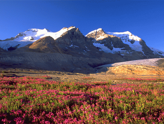
The next two days would take us to Banff, Lake Louise, the Icefields Parkway, Jasper and Dawson Creek Canada, the beginning of the Alaskan Highway. Banff was a ski resort town for sure and while it was summer, it was still booming with tourists and reminded me of towns like Vail in Colorado. Banff and Lake Louse area are the beginning of the Icefields Parkway, and the gateway to the Canadian Glacier National Park. Words cannot describe the beauty of this 100 mile drive but 1000 pictures can try as my camera went thru battery after battery and two 8GB memory cards in one day. There were glaciers everywhere it seemed, each one bigger and more beautiful than the other. Sharp rocky mountain peaks that reached up to the blue skies. Clear blue water mountain lakes and rivers greeted us everywhere and around every curve in the road was another picture postcard image. There is one thing to keep in mind though, there is only on gas station on the parkway and gas was nearly $9 a gallon there, our Jeeps were thirsty but not that thirsty. For those looking for an unforgettable afternoon there was the glacier tour via an ice bus on the huge Columbia Glacier near the north end of the parkway. The Columbia Glacier visitors center gave one a good understanding of what glaciers are and how warming trends over the last 100+ years have made even the mightiest of glaciers retreat considerably. As we continued our journey, the beauty of the area continued to amaze us as did some of the many natural wonders like cascading waterfalls and an abundance of wildlife along the road ways.
We arrived at Dawson Creek during the late afternoon on day 7. Dawson Creek is the beginning of the Alaska Highway which was built by the US Army Engineer Corps in World War II in just 6 ½ months. It was the only land route to get troops and supplies to Alaska from the continental US. While todays road is a vast improvement over the original road, many sections of the original road and some original bridges are still intact along the route. There was a Walmart in Dawson Creek so we did some re-supply that evening before dinner and cruised the town.
The next morning we assembled at Mile 0 of the Alaskan Hwy for some required picture taking and the next part of our journey began, 1422 miles to the end of the Highway in Delta Junction, AK then another 100 miles to Fairbanks, AK in just 6 days.
The Alaska Hwy was an interesting drive, lots of history, some beautiful sights and some great little towns like Watkins Lake, White Horse, Haines Junction and Tok. We say our first Grizzly bears and then more and more bears of all types the next few days. This part of the drive most of us encountered some carnage to our Jeeps, rocks and plenty of them on the last few hundred miles of the Canadian portion of the highway which was under construction and mostly rough gravel roads. Not one of us escaped windshield chipping and cracks. After a while we were vying for bragging rights for the most stars or the longest crack. One of the interesting places along the way was the Sign Forest at Watkins Lake, everyone that goes thru there posts some sort of sign and Jeep Expeditions was no different. In Whitehorse, the capital city of the Yukon there was a lot of history to check out and another Walmart for another re-supply for those who needed supplies.
Coming to the end of the Alaskan Hwy we finally came to the US Border where after showing our passports they actually asked us what our purpose of coming to Alaska was, what we planned on doing and how long we were going to stay. Seriously? We are all US Citizens and we were going into our 49th state from Canada. They dont ask us those questions when we cross the border from Mexico into Arizona. Oh well, it was just great to be in Alaska finally and we would be on our way to Tok and our nights stay before moving on to Fairbanks.
Day 11, I think it was today we saw our first moose. huge, lanky and clumsy looking creatures but something for sure to get pictures of time and time again. Today we would make it to Fairbanks by noon. It gave us all time to get oil changes, lubes and tires rotated as we have driven 4000 or so miles by now and a day of rest and pampering of our Jeeps was needed. Fairbanks is a town with some areas that reminded me of south Phoenix, run down, depressed and industrial. There was plenty of evidence of a once booming downtown with hotels that were now weekly rental units, closed businesss and just run down. But hey, tomorrow we were heading to the Arctic Circle and it was time to rest after taking care of our Jeeps and prepare for the next few big days.
The Dalton Highway a/k/a the Haul Road made famous by the TV reality show Ice Road Truckers is the land route to the Arctic Circle in Alaska ending at the oil town of Prudhoe Bay at the Arctic Ocean. The Alaska Pipeline parallels the Dalton for much of its length and is an impressive sight. There are a few places worth taking the time to check out along the way to Prudhoe Bay. A few miles south of the Dalton you will find an interesting place called The Arctic Circle Wild Wood General Store. Its 200 miles south of the Arctic Circle but it still is worth checking out if you are in the neighborhood. From the artfully decorated fresh outhouses to the main gift store/museum and some interesting conversation with the proprietor, this place you will soon not forget. Just across the Yukon River Bridge is a BLM Visitors Center, a small one but worth checking out and on the other side of the road is a truck stop that you probably want to fill up with gas. A few miles up the road you will want to stop at the Hot Spot for a one pound gourmet burger, that is where the truckers from Carlile Trucking (Ice Road Truckers) eat and where if you make mention of Lisa or any of the other shows stars they will give you their very pointed opinion. The next stop along the way was the Arctic Circle rest area where its picture taking time of our Jeeps at the signage for future bragging rights. Make sure you spend some time at the Arctic National Park Service Visitors Center which has some great interpretive displays. We camped that night at the Marion Creek Camping area, a nice improved government campground with toilet facilities.
The Dalton is a 3 day trip for some and perhaps a 4 day trip for others and day two for us would start off with filling up our gas tanks and enjoying the truckers breakfast buffet at the Coldfoot Truck Stop. Tanks topped off and bellies full, we hit the cold and rainy Arctic road to Prudhoe Bay. The road being wet made for an interesting drive with the dirt surfaces becoming slick but none the less, the big rigs didnt slow down and didnt yield an inch of road to oncoming traffic. The Dalton is not a road for the timid especially in foul weather.
The further north we got the less trees we saw until the landscape became a sea of green grass for as far as we could see. We heard stories of how herds of caribou were seen a day or two earlier but weve not seen one yet. By late afternoon, we arrived at the furthest north we could go in Alaska at Prudhoe Bay. We had called for reservations a few days earlier as required so that we could go thru the background checks prior to our guided tour of the oil fields. Security is tight here due to the high value of the oil fields but you dont drive this far and not tour the fields and dip your toes in the frigid waters of the Arctic Ocean. For the sum of almost a buck a minute, you will get to spend an hour seeing the things that most people will only see on TV and get a few minutes to swim in our northern most ocean, if you are brave or crazy enough. I put my foot it for a few seconds, Russ got in up to his knees, his exact words were its really cold for a few seconds and then your legs get numb. When our tour was over we had dinner at the Arctic Caribou Inns buffet, headed over to the Company Store fueled up and began the trip back to Fairbanks.
South of Prudhoe we saw our first caribou in the distance, not a big heard, more of a platoon but it was still exciting. As darkness fell late into the night, the fog on the highway made driving interesting especially over the treacherous Atigun Pass but we made it over and to the other side slowly and without problem. We decided due to the bear warnings for Galbraith Lake Campground to push on to Marion Creek again where we finally arrived at 2am.
We awoke to Day 14 of our journey to dry blue skies and an abundance of sunshine. I could see that today would be good for pictures that we couldnt get due to the rain of the prior two days. Breakfast today, you guessed it, the truckers buffet at Coldfoot followed by a topping off our gas tanks again. Stops for pictures again at the Arctic Circle rest area, Finger Rock and points in between were planned. Lunch time would have us at the Hot Spot again for their one pound burgers and a wash down of our Jeeps at the high flow artesian well nearby. The wash down wasnt that successful despite the high volume of water and pressure as the Alaskan mud just stuck to our Jeeps like glue. We decided to bypass the truck stop at the Yukon River for fuel and by the time we got to the next opportunity for gas 60 miles north of Fairbanks, some of us were running on fumes.
After a close encounter with a couple of moose on the highway, we finally arrived back in Fairbanks where we cleaned up and a few of us decided to check out the Great Alaska Salmon Bake for dinner. This was a great idea, besides being an all can eat buffet of prime rib, wood grilled salmon, cod and all the trimmings, this place was also an outdoor museum of railroad and mining equipment and an old town reproduction that looked like something out of old Dodge City. The salmon by the way was most excellent! Dinner done and touring over, we all headed back to bunk down for the night in anticipation of seeing Denali National Park the next day.
With our departure from Fairbanks, our trip is now at the half way point. Denali will be a departure point for the group who will be splitting up and heading in different directions on pre-planned routes home, some by ferry.
The drive to Denali was pretty much no different than many of he miles behind us. We were first greeted by the town of Denali, a typical alpine type tourist town. The group made it to the National Park visitors center and spent some time there viewing the short movie and the interpretive displays. Back to our vehicles we headed into the parks interior for a glimpse of the elusive Mt McKinley that hides in the clouds 3 out of every 4 days. Today we would find out that this and the next day would be one of those 3 days.
The drive into Denali offered some breath taking scenery and was well worth the time. Unfortunately, you can only drive about 15 miles into the park where you have to turn around and head back out. Only tour busses can go the entire 90 miles of the Denali Park Road and those tours take 10 to 12 hours, more time than most of us wanted to spend on a tour bus. To me this was probably the most disappointing part of the trip but over the next few days, we would forget about what we werent able to see in Denali as the road ahead would continue to deliver.
July 16th is the start of our journey home. My group left Denali in the morning, it was cold and raining again but by late afternoon, things would clear up. Our route today would be the 100+ miles of dirt highway called the Denali Hwy, the original route to Denali NP.
The first part of the day there was little to see because of fog and low lying clouds but as things started to clear the landscape came alive with snow covered mountains and glaciers. By lunch time we saw what appeared to be a huge glacier off in the distance and decided to stop at the MacLaren River Lodge for lunch. Our hosts there told us that the river next to the lodge was named for the glacier six miles to the north. We were also told that we could reach the glacier by taking BLM and mining roads right up to it. That was exciting to hear and after some pointers, directions and warnings we headed off for a close encounter of a glacier kind.
The BLM road was rough and full of water filled potholes. Beavers build dams on the road making the trip more interesting. At the halfway point to the glacier, we came to the first of two river crossings we were told about. There were two guys there on expedition type motorcycles who decided against trying to cross. The water was moving pretty good but it didnt look too deep. John told me that I had the 7 lift and he would be ready to winch me out if necessary. So ignoring all of my experience and throwing caution to the wind in the name of exploration, I slowly crept from the trail into the river. Things were going well until I was about halfway across, the water was up to my bumpers (over 20 inches) and the guys on the shore were taking pictures. All of a sudden I felt the front end drop a bit and then being pushed downstream. Didnt take me long to put the tranny into reverse and scurry back to the safety of the solid trail. Someone shouted out awesome, I just let out a sigh of relief. One good thing came out of the attempt, the water volume going thru my wheels washed off the mud from the Dalton Hwy that a car wash couldnt. We turned around, went back to the lodge and admitted defeat.
Back on the road for the day, we stopped a few more times for pictures of more glaciers and then to our destination that night, the old mining town of Chitina where we would stay in a restored turn of the century hotel for the evening before heading to McCarthy and the Kennicott Glacier.
The next morning we started off on the 60 mile trip to McCarthy and Kennicott Mine and Glacier. The tour books didnt mention it was a dirt/gravel road that was narrow and windy in places but that didnt matter, it was a wonderful 60 miles loaded with scenic views. We also didnt know that the way into McCarthy was a foot bridge where we would catch a shuttle van to the town and the Kennicott Mine, now a National Park.
McCarthy is a step back in the past. Well maintained buildings as old as 100 years fill the town. While the main industry is tourism, other than the shuttle bus, I didnt feel like I was in a tourist town. The shuttle then leaves the town to the Kennicott Mine. The mine buildings are in the process of being restored and the NPS is doing a great job of it. The mine sits on the mountain side above the glacier of the same name. It was one of the coolest places weve been to so far and we could have spent another day just exploring but we were satisfied with spending several hours there and taking hundreds of pictures of the old mine buildings and the magnificent glacier below. With the afternoon getting shorter it was time for us to leave and meet some of our group again that night in Tok.
The nice thing about Alaska in summer is that it stays light well into the night. We left McCarthy and while we didnt get to Tok until about 11pm, it was pretty much light most of the drive. We settled into our motel and looked forward to a good nights rest as it had been a long day.
Its day 18 and we are departing Tok for the old mining town of Chicken, then Eagle along the Yukon River. The road to Chicken is dirt and gravel with scores of RVs heading both north and south. Chicken is a tourist town but an interesting one and a must see on any trip to the area. We had a lunch of fresh Alaskan Cod bought a bunch of souvenirs and hit the road again for Eagle. Now I am not sure why we went to Eagle other than it has historical significance but it is another 60 mile dirt road that today made for an interesting drive. Its raining now, the road is hard packed mud and its slick. There are no guard rails and its a long way down. There were some areas where the road was actually sliding down the hill and hills that were sliding on the road. The trip to Eagle took nearly 3 hours but it was a neat little town that closed up at the stroke of 5 every night. It was around 5 that I decided I didnt want to take the chance of the road washing out and getting stuck in Eagle so I left the other 4 in our group who decided to stay at a B&B along the river and got out of Dodge. While the rain continued the entire way out, the road didnt seem be getting any worse and a few hours later I found myself back on the road to Chicken and panning for some gold in the stream that paralleled the road. No luck on the gold panning and an hour later I decided to make camp and hope for better weather in the morning.
Seven in the morning day 19, the its still wet and foggy outside and its cold. I made a quick breakfast, broke camp and drove towards the Alaska rest area a few miles west of the Canadian border and try to contact the other guys in Eagle via the ham radio. I was in luck John and Tommy were on the road and heading towards me. The ham radio had a clear signal of them probably 40 miles out. I told them I would cross the border and scout the road to Dawson City. A few miles down the road in the thick fog was the border crossing, after our first encounter entering Canada from Montana I kept my fingers crossed.
The border guard greeted me with a smile and bonjour. I greeted him back in French. He commented on how well my ZJ was equipped and asked me my purpose of coming to Canada to which I replied, tourism, exploration and on my way home to Arizona. He welcomed me to Canada and told me to have a safe and enjoyable trip. Wow was I really in Canada? I got back on the radio and told John that the border crossing was quick and easy and made way towards Dawson City. The further east I got, the fog and cloud cover retreated and the light rain gave way to some sun and some blue in the sky. There are no facilities on the Top of the World Highway and the last gas was in Chicken. Now I was on empty and stopped to move five gallons from one of my Jerry cans. I would have to use my last five gallons further down the road before I got to Dawson. It pays to be prepared in areas like this.
I reached the top of the mountain leading down to the Yukon River and Dawson City and found a side road where I was able to take some great pictures of the town and countryside below. Continuing down the road to the river the ferry crossing came into sight, it is the only way across the river and I had to wait for the 3rd crossing for my turn for a boat ride. It was an exciting ride into Dawson City on the ferry. The town had an old world charm and I would regret having not spent another day there as there were plenty of historical sites and museums to explore. Once back on dry land, I headed to the Dawson/Yukon and NW Territories visitors centers and gathered information and brochures I could use in the days ahead. An hour later, John and Tommy were calling me on the ham radio to say they were coming down the big hill to the ferry.
Reunited with part of the group again we did some exploring and filled our thirsty Jeeps with gas. My gas bill this time was $189, I would use the $11 change for dinner at Sour Dough Joes. After dinner we decided to walk thru some of the shops on main street and get some mementos of our visit. I tried to negotiate the price on a mammoth tusk but the owner wasnt there to talk so I left without a piece of history ten thousand years old. We left Dawson City for a night at the Yukon River Lodge at mile post 0 of the Dempster Highway that would take us as far north as one can drive in Canada and the town of Inuvik.
Its July 20 and we will be home in just ten days. Starting at mile 0 of the Dempster Hwy the signs are very clear that there are no emergency services, no police, no hospitals, no help for the next 500 miles. The guys at the lodge told us this morning that we looked to be pretty well prepared for the Dempster and that they are always driving up to tow back a tourist whose street tires couldnt make it. Fourteen hard hours later, after several bear sightings and two river crossings, we arrived at our destination, Inuvik, NWT, Canada.
Along the way we stopped at Tombstone National Park, the only gas station at about 250 miles, the Arctic Circle rest area and the NWT/Yukon border rest areas. But the reason for the trip was Inuvik and weve gotten here for the last day of the midnight sun for 2011. The midnight sun quite simply is a sun the never sets and tonight the sun would not disappoint us under the clear Arctic skies.
Just as promised, the sun stopped setting at midnight at the two oclock position and started moving horizontally to the east. It was one of the coolest phenomenas of nature Ive ever seen and almost made up for me not seeing the Northern Lights. Unfortunately, I could not stay away much past 3am as I continued to watch the sun travel to the east despite the bright daylight in the middle of the night. I woke up again around 7am to see the sun now rising back into the sky to the east.
Before we headed back south on our homeward journey, the three of us stopped at the world famous Inuvik Arts Festival. Ok, after we got in for free being seniors or elders as they referred to those of us who have grey hair, there were some cool but very pricy items to look at. After that we moved on to the museum at the edge of town then back down the highway and paved roads 500 miles to the south.
The trip south normally would have been uneventful but high water levels on the river closed the ferry down for what we were told could be up to 3 days. They were trying to build up the river banks where the ferry landed and after most of the day the construction efforts worked and the ferry was running again, but only half full for safety. As we got to the Arctic Circle, it was getting dark (11pm) and it was clear that this was the first day that the midnight sun would not visit this area again until next spring. The halfway point was still more than an hour away and the gas station was long closed as was the hotel and restaurant so we camped in our Jeeps for the night as we could not go on without gas.
The sky was getting light before 6am already and the gas station would open soon. With little waste of time, we filled our Jeeps and hit the Dempster for the last 250 miles to pavement. At high noon, we arrived back at mile 0 and gassed up and lunched at the Yukon River Inn. John and Tommy wanted to go spend another day visiting museums in Dawson City and I wanted to get moving back towards the US. We parted company for a few days while they explored Dawson City and I make my way back to the border to meet up with Russ and planned to meet back up with John and Tommy. I would make it as far as Whitehorse late tonight with plenty of stops along the way at historical places and for pictures.
Leaving Whitehorse the next morning I made time to stop at the Berengia Museum as I love paleontology and such. It was well worth the hour or so I spent there and I recommend you check it out when in the area. It was obvious to me now that my expedition was getting close to the end. I would head to Watson Lake today then south towards Vancouver. It was on the road way south from Watson Lake that I saw probably 50 or so bears in the two partial days I spend on this road. Some of the road was gravel, most was paved and many miles of it passed thru old fire ravaged woods. I would call it a night at Dease Lake where my gas was running low and leave again in the morning.
The next two days to Vancover would take me thru towns like Smithers, Prince George, Lac La Hache, Cluculz Lake and Ft Langley. There were plenty of stops for picture taking and lots of things to see. Lumber is the main industry down here and mills are everywhere it seems and piles and piles of finished boards are staked up and ready for transport via truck and rail. As I arrived at Ft Langley on the 25th I was able to talk to Russ who was just down the road in Vancouver and John and Tommy who were a good days drive behind me in Prince George. We made plans to get together again in Seattle the next evening so I settled down in my hotel and planned to sleep in a bit the next morning.
Wow, just 4 more days to home and in a few hours I would be back in the good old USA with cheap gas in the high $3 range. I spent my morning at Ft Langley, a restored fort from 200 years ago with the oldest original building being 171 years old and the oldest building in the west. It was a great visit full of history with plenty of actors in period costume as your hosts but after spending two hours there I was ready to head for the border. An hour later and after a short wait in line, DHS cleared me and I was excited to be back home and yet a little sad that my journey is coming to an end. Lunch at Mickey Ds and off to Seattle to meet up with Russ and Ziggy.
One of the first things I saw in Seattle was the space needle that is the city landmark everyone recognizes. Russ was getting off the ferry just north Seattle from Vancouver and we made plans to meet for pictures and dinner. We found a park high on the hill overlooking the city which made for great picture taking of the harbor, downtown and of course the needle in the sky. But it was still daylight and the best pictures from this point would be after dark so we headed down to the water front for dinner at a restaurant famous for acres of clams. Well I ordered the acres of clams dinner and while it wasnt an acre, it was quite filling. By now it was dark and time for us to head back up to the park for what would be some magnificent pictures of Seattle at night. We hoped that the clouds in the distance would lift by morning so we could get a glimpse of Mt Ranier.
Morning came, maybe a little too soon but we had things to do and see so we hit the road hoping to see Mt Ranier, it wouldnt happen as the clouds would keep this huge volcanic mountain hidden from sight. We drove on to Tacoma and bought some gifts and such then headed down the road Mt St Helens, Portland and eventually Mt Hood. We got some good pictures of Mt Saint Helens and Mt Hood and moved on to Bend, Or for the night.
Just how much can you pack into 3 days? Lots! We left Bend, OR in the morning and headed to Newberry Volcanic National Monument. Besides paleontology, geology is a second love of mine and volcanoes a fascination. Newberry has lots to explore and offer and we took most if not all of it in before we left for Crater Lake, another volcano. Crater Lake is a beautiful area that I could probably have spent a few days in but I was longing for home. While me and Ziggy toured the rim of this ancient volcano, Russ hiked down a trail to the water and took a swim. The snow was measured in feet in some areas and he took a dip in the lake, dont tell Russ but I think he has a crazy streak in him. We kept in touch via his ham walkie talkie and the plan was to meet up at the south entrance. Timing was perfect and we ended up at the only restaurant open for miles around 8:30pm and with our luck it was a buffet. The hungry travelers had dinner before leaving for our next nightly stop in Klamouth Falls, OR.
Two days left on our trip and the next morning Russ and I parted company, he was eager to get home and I had more volcanoes to see. My plans for today were to visit Lassen Volcanic National Monument, Lava Beds National Monument and to get some pictures of Mt Shasta. Lava Beds NM was not only very cool but was full of history with cavalry battles and Indian wars. Mt Shasta reached up to the clear blue sky and I got great pictures of its snow capped peak. Finally, at Lassen Volcanic Monument I realized that this national monument would easily take two or three days to see it all and I told myself that someday I would return. Now it was a sprint home to Arizona and I drove as far as Firebaugh, CA when at 3am. I called it a night.
Last day the expedition is coming to an end. I plan on making it to Phoenix by nightfall. Its been a long month on the road and I am more than eager to see my fiancée Carol and my two dogs Cassie and Louie. After just three hours of sleep I wake to the rising sun and hit the road again. Made LA around 1pm and 6 hours later I am seeing the far west outskirts of Phoenix
its good to be back home.
For a more detailed account of our trip visit the daily blog for the Arctic Jeep Expedition at: http://arcticjeepexpedition.blogspot.com/
So what do you need to do your own Arctic Expedition? Well you need some friends because in these areas you do not travel alone. You need to be well prepared and have enough supplies for several days at minimum. Be ready to change plans as necessary. Plan ahead, far ahead. Jeep Expeditions had been planning this trip for nearly 3 years. Our primary resource for information were a book called The Mile Post which is a comprehensive guide book of not only the Alaska Hwy but all major roads in Western Canada and Alaska. We also relied heavily on internet searches, tourist bureaus and National Geographic and Delorme Maps. Our Garmin GPS units were a great navigation aid. We had communications covered as all members of our group had ham radios plus we had two satellite phones courtesy of Iridium (www.iridium.com).
Jeep Expeditions (www.jeepexpeditions.org) is an organized club of explorers from all walks of life headquartered in Arizona. In just five years Jeep Expeditions has become the number one Jeep exclusive overland exploration club anywhere.
REFLECTIONS OF THE TRIP OF A LIFETIME....................
Three years of planning. Dozens of books and maps. Conference calls, hundreds of emails and posts. Members signing up and dropping out and finally, the Arctic Jeep Expedition begins.
I look back over the past three years and the last five weeks and think what went good, what didnt. What resources were invaluable and which werent and what worked and what didnt.
Would I do it all over again, you bet! But it would be somewhat different the next time given the experience of the 1st trip. Probably the best written resource for this type of trip is the Milepost book that essentially takes one over most of the roads we travelled with a wealth of information. However, do not count on even the most current issue of the Milepost for accurate information on available services, especially gas stations as we found way too many food and fuel stops closed along the way. Carry at least 5 gallons of gas just in case.
Canadian roads are the best anywhere. Clean and well maintained, even the dirt roads. Most of the travelled highways featured rest areas and government campgrounds every 25 to 50 miles. That included every road we travelled except the Demster Highway. The government campgrounds were modern and clean. Many were lakeside, all had toilets, picnic tables, fire rings and BBQs. The ones I drove thru offered free fire wood and all that for $10 to $12 a night. Rest areas almost always had kiosks that gave information on the area.
Alaskan roads are for the most part the worst that I have driven on in my life. In the defense of the Alaska DOT, most of their problems are due to the continual freezing and thawing out of the ground below the road surface. The dirt roads are actually better than many of the paved roads we were one in my opinion.
One thing I found out early is that the AAA campground and motel books do not list anywhere near all of your options for many given towns and totally miss out on others. The campground book might list 1/10th of the campgrounds in Canada and Alaska. The motel book maybe 20%. It seems as if the only ones listed are the ones that are AAA approved. There are many equally good properties along the way not listed in the AAA books that are deserving of your business.
GPS. I was really counting on the two Garmin Nuvi 1490s in my rig along with the Garmin GPSMAP 478. Why 3 GPS? I used one Nuvi for most navigation and searching for POIs (points of interest like gas, food, camping and motels), the second with Garmins EcoRoute HD device to display critical vehicle stats like exact temps and such (a very cool feature) and the GPSMAP 478 for off-road with current Garmin Canada and US TOPO maps. Garmin is really good on POIs in the lower 48 but really poor, no exceptionally poor when it comes to Canada and Alaska. I was using Garmins latest 2011 North America software in all 3 devices so it cant be blamed on outdated software. Woody had a TomTom which seemed to have more POIs in Canada, especially gas stations. On a trip like this with 10-14mpg vehicles, gas is critical. In one case I had to use both of my 5 gallon reserve cans to make it to the next station due to inaccurate info both on the GPS and print books. That is cutting it too close. The big disappointment in the NUVIs is that one of them just died 10 days into the trip and the other was really bad at keeping in touch with the satellites. Fortunately the external antenna on the 478 had little problem with satellite reception so for the most part I always knew where I was.
Communications. Leave the cell phone at home, unless you were in the area of a big city like Fairbanks or Anchorage, much of our Alaska was a big black hole. Same for Canada, especially when we hit the Yukon. We carried two Iridium Satillite phones to keep in touch on a daily basis and for emergencies. Many of us also had SPOT devices that kept great tracks for friends, fans and families to see where we were and were we had been. The weak part of the SPOT is that it only keeps information for the last 7 days of your journey so one could only see the trail of the last week. The SPOT also has a 911 feature that will send for search and rescue just about anywhere in the world.
Entertainment. Bring your CDs, MP3s and DVDs. I could not get a signal on my Sirius/XM radio pretty much anywhere north of Banff. With only 1 CD with me, I now have all 23 songs memorized which will be great in the Karaoke bars.
Costs of Trip. Do you really want to know? Its not cheap. Once we entered Canada we paid anywhere from $1 more per gallon to $4 more per gallon for gas. The highest prices for gas were in the more remote areas. My most expensive fill up was $179. I used about 900 gallons of gas, about the same or a bit less than an RV. Surprisingly gas in Alaska was more than gas in California and ranged in the mid $4 to $5 per gallon. Food is also more expensive. John joked about wanting to buy a $15 hamburger. Once we got to Canada and even Alaska, $15 hamburgers were the norm although they were good and were as much as ½ pounders. Ice, $5 for an 8lb bag. Milk $5 a gallon. Soda $2 and more per liter and bottled water, I paid $5 a gallon at one convenience store.
Carnage. Well lets see. I broke 3 grade 8 bolts that secured my quick discos to my sway bar. Drove the last 1500 miles home with the sway bar discod. It handled well though probably due to my Fox Racing Shocks. I blew the top radiator hose and the bypass hose. Oh and my thermostat got stuck in the close position. Kevin had to drop from the main trip in Montana due to rear D60 problems that required a major repair. Woody totally FUBARd his front axle in Washington state on the way back in the ditch from hell. It looked like TrawlerCats rear spare tire carrier (bumper mounted) was pulling away from the Jeep body in a bad way. Everyone but Russ will need to have their windshield replaced from stones thrown up by trucks. At least 3 of us have multiple hard hits to the glass and long cracks that developed immediately or within a day. Russ had some tire punctures that he found out about when the WKs tire pressure monitor warned him of low pressure. John had his $100+ Ham Radio antenna stolen in Inuvik at a nice hotel. I found out that while my roof rack can easily hold 400 lbs, that the factory bars cant handle the vibration and I ended up with a golf ball size dent in my roof from the HiLift Jack. I am sure there was a bit more but only Woodys axle problems (the forces of nature went so far as to rip off the passenger side steering knuckle and bent the axle tube) required a tow back home as it was not repairable at the point of destruction.
So what would I do different the next time?
I would not waste my time at Glacier National Park in Montana. If you want to see Glaciers head to the Icefields Parkway in Canada and Alaska because unless you are up to a long hike or an $800 helicopter flight, you wont see any in Glacier Montana. And although the Icefields Parkway was a very beautiful day trip (less than 200 miles) I would probably make that a separate trip over a couple of days not connected to Alaska.
BR /> Would I do the Alaska highway again. Maybe but I think I would come up from Vancouver to Price George then to Dawson Creek. The Alaska Hwy, aka the ALCAN is full of history and driving its length once probably will suit me fine.
I am thinking next time take the ferry from Bellingham to Vancouver Island. Drive the island from south to north and take a ferry to Prince Rupert. From there I would take Rte 16 to Rte 37 and head north. At 37a I would head west to Stewart, CA and Hyder, AK to see the glacier there which I was told was awesome. Heading back to 37 then north to the Alaska Hwy and east to Watson Lake where I would put up a much bigger JE sign in the Sign Post Forest. Take the Campbell Highway north to the Canol Highway.
Take the Canol Hwy north to the end and then head south to Whitehorse. From Whitehorse take the Yukon Highway to Dawson City. Since I have been to Inuvik already and experienced the midnight sun (and excellent weather) there I would skip the Dempster Highway.
From Dawson City take the top of the World Highway to Chicken and Tok (bypass Eagle this time, not worth the 140 or so miles round trip on a shelf road in my opinion).
Take Tok to Fairbanks and run the Dalton Highway again. Head to Anchorage via Denali (to see Mt. McKinley). Enjoy the sights to see including the areas that Russ visited on this trip.
Make another trip to Kennicott Mine and Glacier. I think it was well worth the trip but this time pay for the drive across the bridge.
Head home via Haines Junction to Haines Alaska and catch the Ferry back to Washington.
And most importantly, NO schedule. Take as much time as needed to see what you want to see. One thing we found out is that reservations were not necessary so ending up at an unplanned stop for the night should not be a problem.
|
|
|
|
Jeep Expeditions is the PREMIERE Jeep Exclusive Expedition/Overland Adventure CLUB Anywhere!
Jeep Expeditions is a non-profit corporation registered in the State of Arizona.
The state recognizes us as a fraternal
organization, we prefer to say we are a club. Our members and volunteers are dedicated to the exploration of
this great land for the educational value, historical value, scenic beauty, the geology, paleontology, the camaraderie of people
who share the same interests and to escape the confines of civilization if only for a few days. Our organization and members adhere to the
standards of "Tread Lightly" and "Leave No Trace".
Jeep Expedition Members enjoy adventures that vary in length from one day, a weekend, long weekend, week long, two weeks and like our Arctic
Expedition in 2011, a full month. Don't worry, most of our trips are one day and two day trips. We are Family Friendly and we have
a number of members who bring their friendly "Jeep Dogs".
Copyright © 2006 - 2023 Jeep Expeditions, Inc. All Rights Reserved.
Jeep Expeditions Group, Jeep Expeditions, Inc., Jeep Expeditions, JeepExpeditions USA, JeepExpeditions.org. JeepExpeditions.club,
JeepExpeditions.com and other names we use along with domain names owned by Jeep Expeditions, Inc are all Copyrights & Trademarks held by
Jeep Expeditions, Inc. d/b/a "Jeep Expeditions" We also own Copyrights and Trademarks to our logo, Trip Decals and other variations of such as shown
on this website, our Facebook Page, Twitter and Instagram accounts.
Jeep Wrangler, Jeep Wrangler Unlimited, Jeep Wagoneer, Jeep Commander, Jeep Grand Cherokee, Jeep Liberty, Jeep Cherokee, Jeep Gladiator,
Jeep Scrambler, Jeep CJ, Rubicon, Renegade, Laredo, Overland, SRT-8, HEMI, Rock-Trac, Command-Trac, Selec-Trac, Quadra-Trac, Quadra-Trac II,
Quadra-Drive, Quadra-Drive II, SmartBeam, Jeep, the Jeep logo, and the Jeep grille are registered trademarks of FCA US LLC. Throughout this
web site all the preceding marks & logos are used for identification purposes only. JEEPEXPEDITIONS.ORG is an independent web site and is not
affiliated with FCA US LLC. Other trademarks and images used throughout this web site are the property of their respective owners, have no affiliation with
Jeep Expeditions and are used for informational and identification purposes only.
Terms Of Use: You may not hold the owners, operators, members (or any associated parties) of the
JEEPEXPEDITIONS.ORG or any other Jeep Expeditions, Inc /Jeep Expeditions Group web sites liable or financially responsible for any damages
including -- but not limited to -- emotional, physical, or financial damages incurred during or after the use of this web site. Use of this
web site constitutes an agreement to these Terms Of Use.
|
|