
IMPORTANT NOTICE!
Activities and vehicle modifications appearing, described, recommended, or linked to on this web site may be potentially dangerous.
We do not endorse any such activity for others or recommend it to any particular person.
These are simply the experiences and opinions of the writers.
If you choose to engage in these activities it is by your own free will and at your own risk.
Any and all modifications will likely cause a vehicle to behave differently than stock - some modifications may significantly increase your risk for an accident
or equipment failure when driving the vehicle or be dangerous in some driving situations.
Use common sense when engaging in any activity or making any modifications.
Do not take unwise risks, consult a certified professional if you are not sure of something, if you are uncomfortable with your mechanical ability, if you don't
have the experience to do a project, if you have not received proper training and education for the job you are thinking about doing, or if you do not have the proper tools, equipment or safety devices to do the job you are considering.
The owners, operators, members (or any associated parties) of the JEEPEXPEDITIONS.ORG web site and the writers / authors of the content contained within this web
site are not liable or financially responsible for any damages including -- but not limited to -- emotional, physical, or financial damages incurred during or after
the use of this web site or any content contain within.
|

Trip Report: North Rim of the Grand Canyon - Aug 4-8, 2007
|
The GRAND CANYON - like no other !
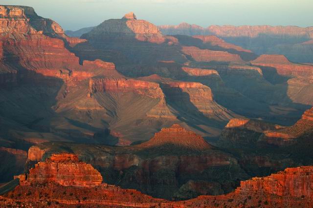
There is one thing for sure, the Grand Canyon is far more than Grand. Its incredible and the North Rim is the place to go to see more of the Grand Canyon with NO crowds and to see it almost entirely from dirt roads and trails !
Nearly 25 signed up for this trip but in the end only 7 of us made it including some guests from Holland who belong to Jeep clubs in Europe and own several Jeeps. Myself (Mike) and Carol my better half, Sam White and his wife, Irv Kanode, Steve VanHerpen, Jim Galbraith, Chris Linford and his wife and Tim Lewis and his son. The most memorable words I remember from day one were this view alone made the whole trip worth it! That pretty much sums up the whole trip, because no matter what you saw an hour ago, the next view seemed to be even more spectacular.
We started our morning at 4am in Mesa, AZ. After fueling up the hungry beast, my highly modified 1982 Jeep Wagoneer, whose new gearing now gives it 7mpg, we headed to Flag to meet up with more of our group. After a fuel stop in Camp Verde we arrived at the McDonalds on 89 around 7:15, grabbed some egg McMuffins and fueled up again. Our destination the 1st day was Fredonia and then to Toroweap overlook. The convoy stopped in Marble Canyon for fuel drove past Jacobs lake where we picked up another member of our group and got to Fredonia just before noon where we again fueled up and moved on to the trailhead for lunch.
The next leg of our trip would take us thru a dusty 65 miles of wash board dirt road with some pot holes and mud scattered here and there. Just after 2 pm we made it to the Tuweep Ranger Station, no one was around so we got some brochures, took some pictures and moved on to Toroweap, the most remote and least visited part of the North Rim. The road from this point was no longer maintained, so as to keep its primitiveness and restrict the number of vehicles that could access the area according to the NPS. While the road was nothing that could stop our Jeeps and CDN trailers we were pulling, we no longer could maintain anywhere near the 30mph we did the 1st 60 or so miles due to the change in road condtions.
Eventually, the sign at the fork of the road told us were were there, to the left was the campground and to the right was the road to the rim. We took the road to the campground and what a surprise, a nice campground complete with real outhouses ! Everyone staked out their claim to a site and some set up camp, others dropped their trailers and headed to the rim. While the view from our campsites was nothing less than spectacular, the view from the Toroweap overlook was incredible ! Not for the weak as there are no fences or barriers to keep you from walking right up to the edge and looking straight down about 2/3rds of a mile to the bottom and the Colorado river ! With nothing to obstruct your view into the inner gorge, Toroweap is probably the best place in the Grand Canyon to get a sense of how big it is. Further east at the South or North Rim, you can sense its vastness in a more panoramic manner. The canyon sprawls before you, impressing with its horizontal size, but it never quite gives you an adequate sense of its vertical scale. At Toroweap, the drop is so deep and dramatic that you finally "get it." There are bigger places on earth than Toroweap but none can give a stronger impression of sheer immensity. There was plenty of picture taking and night one was pretty quiet as it was a long day for all of us.
Day two, the plan was to hit the road by 9am and meet our last member near the entrance to Hack Canyon. Before hitting the road, some of the group went to the overlook for morning pictures, others packed up and went to the optional Lava Falls area to the west of Toroweap, but at just past 9, we all met up again and started the journey north. Not too far into the trip we were stopped by the Tuweep ranger who drove a Rubicon Unlimited, complete with ARB bumpers, Warn winch, nice wilderness rack, lots of LED emergency lights and an M-16 in his gun rack ! A really nice guy he told us Hack Canyon trail was pretty much wiped out again last week by flooding and that our TJs might be able to make it but the Wagoneer was out of luck as it was way too big (but what about my lockers and nearly 8 of lift?), he also suggested we not take our trailers into Hack Canyon to make it easier. We thanked him for his help and hit the road again.
At the entrance to Hack Canyon, we met Sam and his wife. After some discussion, ½ the group decided to try Hack Canyon and the rest of us headed to Fredonia to gas up and stock up on ice and other supplies before heading to the Backcountry office for our permit to Point Sublime. Figuring we had a good 2 hours to take our time and explore for the Hack Canyon group to catch up to us, we did just that, took our time. What we didnt know is that Hack Canyon was all but impassible and the other group was back on the trail to meet us within ½ hour. While we were fueling up again at 67 and FR22 I got a call on the Ham radio from Steve saying the rest of the group was 20 miles down the road at the Backcountry office waiting for us
so much for taking our time !
Finally we got the last permit for Point Sublime and we are on our way. The road didnt start out too bad but it got worse, nothing a Jeep could not easily do but there was one spot that the grocery getter wasnt going to make it. The road was barely 1 lane most of the way with few if any places to pull off to let someone by. Just then we ran into a ranger. I told him there were 7 vehicles, most with trailers and we could not back up. He was not happy and demanded to see our permit when he was satisfied that we were authorized to be there he let me know that he was going to have to back up ½ mile to let us by. Better him than us J . Anyway, just before Point Sublime we passed the camping area, small and not well marked and we continued to the point. Again we are awed by the majesty of the view and the never ending beauty of the canyon. The group with the other permit was already there and they set up their place on a 20x20 rock that was a sheer drop on 3 sides. We had the campground to ourselves. Not anything compared to Toroweap campground. The outhouse was really outside. A big plastic throne with some boards nailed to two posts to keep people in front of you from seeing you. Your other 3 sides were
exposed !
After lots of picture taking, we drove back the ¼ mile to camp and set up our sites. I set up my tent 15 feet or so from the edge, which didnt make it that much further from the road. The sites on the other side of the road had much more room but we just about had filled up the area with our tents and vehicles, there would not have been room for many more. With dinners cooking, some people went back to the overlook to take more pictures. Again with it being a long day, things got quiet quick and everyone got to bed early.
Morning of day 3, despite the fog/haze in the canyon, there were some good opportunities to get pictures of sun rays coming thru the clouds and the sunlight dancing from cliff to cliff in an ever changing display of reds and golds. We packed up camp and headed to Cape Royal and Point Imperial for some more spectacular views and many more pictures. Along the way we stopped at several more viewpoints, never getting tired of the ever changing views, each of which seemed to be just as or even more impressive than the last one. By late afternoon we ended up at the famous North Rim Lodge where we stopped for a while, took more pictures and bought some souvenirs. At that point we could have stayed in the NPS campground which was pretty civilized but since the rest of our adventures were all going to center around FR22, nearly 20 miles north, we decided to stay at De Mott campground which is operated by the Forest Service. Upon arrival at De Mott, there did not seem to be any group camping there so we picked our sites and set up camps
well everyone but Sam and his wife, it was their 40th anniversary (I think) so they decided to rent a cabin for the night at the property next
Just after we got camp set up, Sam and his wife stopped by and said the cabin was small but the shower was really good and offered to let all of us use the showers there. Some of us gladly took them up on the offer and oh how good it felt ! After showers some of us met Sam again at the restaurant and decided to let someone else cook and clean for us that night and it was much better than camp cooking too !
Day 4, so many trails, so little time ! We hit FR22 and headed to Fire Point, the last point in the confines of the National Park. Fire Point had a nice, but small camping area and a spectacular view ! We then headed NW and took in Crazy Jug Point, Monument Point and Parissawampitts Points. Lots more pictures and some really good camping possibilities for future trips. With half the day ahead of us we headed over to Saddle Mountain Point for more spectacular views and more good possibilities to camp in the future. Our last stop of the day was Marble Point which was recently written up in Arizona Highways Magazine. Keep in mind that every place we went to today were on dirt roads, not bad roads but enough to keep your speed down under 30 most of the time and plenty of water holes to throw mud and water all over you. When we arrived at the 1st area of Marble Point I was trying to figure out why the view was different than what I saw in the magazine
I then realized that the trail continued thru a canopy of trees to another opening, one that looked vast. Hopping up into the beast I followed the trail to what I thought was one of the best parts of the trip yet, with camping for hundreds! This part of Marble Point was huge, the flat area that could be camped in was open and treeless for probably ½ square mile. To the west was the tree line, to the east and north east was the canyon and it was magnificent ! Walking thru the rocks that were scattered about we easily found several fossils of sea shells and other aquatic life from millions of years ago. On our next trip to the North Rim, this could be base camp for a few days, you would never get tired of the view and I am told the sun rise and sets are nothing short of spectacular !
Well it was now going on early evening and people were getting hungry and it had been another long but fruitful day. We headed back to camp for dinner and at dark we had a campfire with marshmallows and smores where we talked about the day and the past few days. The discussion turned to Wednesday and what everyone wanted to do as it was an optional day. Some of the group wanted to try a trail called the Great Western Trail that bypassed Jacobs Lake and ended up in Lees Ferry we thought. We all let everyone know what we would be doing the next day and said our good nights and good byes in some cases.
Day 5. Me and my guests went over to the Glen Canyon/Lees Ferry area and got some sunburn and lots more pictures. The Lees Ferry and Glen Canyon area made for more magnificent views and many more pictures. On the way out we stopped at the Navajo Bridge, the crossing between the south and north rims, for more pictures. It seemed like we got to Flagstaff in quick time and dinner at Pizza Hut was in order. After that we hit I-17 and were home by 10pm.
Group two had a much more exciting day that we did on their venture back home. The morning started off on a prophetic note: Sam put his trailer in the ditch. Jim and Irv helped get it out and then they drove over to the gas station just to find it was not to open until seven. The guy kind of rudely suggested they drive to Jacob Lake. (thats what you get when you dont sleep in J ). When they got to Jacob Lake they found that that gas station was also not open yet. So they wandered around, bought cookies and stuff until the kid arrived to open the gas station around 7:45am. They then backtracked through the burn area from last year and picked up fr 205 which is what they thought was the Great Western Trail. This area of the forest is absolutely beautiful. The roads are narrow but well maintained. The ground in that area is flat and well manicured. After much reflection Sam said it reminded him of a city park but without the people. They shortly picked up fr 224 and started the decent. Before long they passed a sign telling them about the burn area ahead and warning that there might be fallen timber. The trail wasnt all that steep or difficult and, even with the burn, quite spectacular. After about three mile they came to the cross road of fr 220. Here is where things should have made some sense but it was such a beautiful morning and the scenery was so spectacular that they didnt give a second notice to the fact that both sides of fr 220 were closed. They continued on east and picked up fr 284c and at the same time signs that they were on the GWT. The road turned north east and became easy and flat for several miles as they entered a very pretty canyon which might be called Valley Canyon. It is noted on the map as House Rock Trick Tank. The road wound around in this canyon for a few miles before turning west and then climbing up the north side where they could look down into the canyon they had just been in. At this point they were still a few thousand feet about House Rock Valley. This area still had a few Pinion Pine and Juniper trees and the views were spectacular. They had excellent views of House Rock Valley, both the Vermillion and Echo Cliffs and quite a view of the Honeymoon trail. In the distance below them, in House Rock Valley they could see a lake and much green. Another warning message that we chose to ignore. After a few miles they started the decent into HRV which was rather bumpy and pretty much straight down. As usual Sam was looking forward to a nice soft flat road to drive on. Never mind that his brand new map had no roads after this point, Irv had a wonderful map of the GWT and it was pretty much correct. The road started out pretty well but now they were on the flats, not very interesting and very dusty. But they were within sight of highway 89A. A few miles later they came to a ranch, passed a few cows and dipped into a few small mud pits. Sam turned north and stopped to tell the others that, while they were close to the paved road, he thought they were off the GWT. No one seemed to want to do the last few miles as it would just be on the flats and in the dust so they continued north and passed a ranch. They came to a small hand made gate and passed trough it. Sam was the first through and so he closed the gate. When Sam caught up to Irv he was a few feet from 89A opening the gate. But when Sam got closer Irv was waving him to pull over. The gate was locked! So they retraced their path past the farm and back onto the GWT. After about a mile they came to the diagonal road that would take them to House Rock Valley road aka 8910 which is a major road in the valley. But then they started coming to the green stuff. Sam was in front and things started getting interesting. There was a quarter mile section of mud ahead of him but there were tracks through it and you could see the dried dust under the mud. They passed at least two other sections of mud before getting back onto a dry patch of the road. Now they were but a half mile from the HRV road. Salvation was in sight. Then Irv stopped. A washout, pretty fresh and steep was just in front of him. They all got through the wash and a few minutes later connected with 8910. Now 89A was but a few miles away on a very good, well used dirt road. After another mile or so Irv stopped again. Another wash out but this time a major drainage with some mud in it. Fortunately he was really stopped to let the rangers get through the mess. They came to one more washout and then came into sight of 89A. Irv and Jim stopped at the message board to read the information. They had been on the trail for a little over three hours but had only traveled 18 miles. Then Irv read the message that the road we had just traveled was closed due to fire danger. Irv and Jim pointed out that if we had attempted the route just a day or so earlier they would have been sucked into one of the mud pits. In the end all worked out ok, we had a wonderful time and didnt get much more mud on the Jeeps.
Vist the Photo Gallery for plenty of pictures of this and other Expeditions
|
|
|
|
Jeep Expeditions is the PREMIERE Jeep Exclusive Expedition/Overland Adventure CLUB Anywhere!
Jeep Expeditions is a non-profit corporation registered in the State of Arizona.
The state recognizes us as a fraternal
organization, we prefer to say we are a club. Our members and volunteers are dedicated to the exploration of
this great land for the educational value, historical value, scenic beauty, the geology, paleontology, the camaraderie of people
who share the same interests and to escape the confines of civilization if only for a few days. Our organization and members adhere to the
standards of "Tread Lightly" and "Leave No Trace".
Jeep Expedition Members enjoy adventures that vary in length from one day, a weekend, long weekend, week long, two weeks and like our Arctic
Expedition in 2011, a full month. Don't worry, most of our trips are one day and two day trips. We are Family Friendly and we have
a number of members who bring their friendly "Jeep Dogs".
Copyright © 2006 - 2023 Jeep Expeditions, Inc. All Rights Reserved.
Jeep Expeditions Group, Jeep Expeditions, Inc., Jeep Expeditions, JeepExpeditions USA, JeepExpeditions.org. JeepExpeditions.club,
JeepExpeditions.com and other names we use along with domain names owned by Jeep Expeditions, Inc are all Copyrights & Trademarks held by
Jeep Expeditions, Inc. d/b/a "Jeep Expeditions" We also own Copyrights and Trademarks to our logo, Trip Decals and other variations of such as shown
on this website, our Facebook Page, Twitter and Instagram accounts.
Jeep Wrangler, Jeep Wrangler Unlimited, Jeep Wagoneer, Jeep Commander, Jeep Grand Cherokee, Jeep Liberty, Jeep Cherokee, Jeep Gladiator,
Jeep Scrambler, Jeep CJ, Rubicon, Renegade, Laredo, Overland, SRT-8, HEMI, Rock-Trac, Command-Trac, Selec-Trac, Quadra-Trac, Quadra-Trac II,
Quadra-Drive, Quadra-Drive II, SmartBeam, Jeep, the Jeep logo, and the Jeep grille are registered trademarks of FCA US LLC. Throughout this
web site all the preceding marks & logos are used for identification purposes only. JEEPEXPEDITIONS.ORG is an independent web site and is not
affiliated with FCA US LLC. Other trademarks and images used throughout this web site are the property of their respective owners, have no affiliation with
Jeep Expeditions and are used for informational and identification purposes only.
Terms Of Use: You may not hold the owners, operators, members (or any associated parties) of the
JEEPEXPEDITIONS.ORG or any other Jeep Expeditions, Inc /Jeep Expeditions Group web sites liable or financially responsible for any damages
including -- but not limited to -- emotional, physical, or financial damages incurred during or after the use of this web site. Use of this
web site constitutes an agreement to these Terms Of Use.
|
|