The Jeep Expeditions Group ™ Logo
IMPORTANT NOTICE!

Activities and vehicle modifications appearing, described, recommended, or linked to on this web site may be potentially dangerous. We do not endorse any such activity for others or recommend it to any particular person. These are simply the experiences and opinions of the writers. If you choose to engage in these activities it is by your own free will and at your own risk. Any and all modifications will likely cause a vehicle to behave differently than stock - some modifications may significantly increase your risk for an accident or equipment failure when driving the vehicle or be dangerous in some driving situations. Use common sense when engaging in any activity or making any modifications. Do not take unwise risks, consult a certified professional if you are not sure of something, if you are uncomfortable with your mechanical ability, if you don't have the experience to do a project, if you have not received proper training and education for the job you are thinking about doing, or if you do not have the proper tools, equipment or safety devices to do the job you are considering.

The owners, operators, members (or any associated parties) of the JEEPEXPEDITIONS.ORG web site and the writers / authors of the content contained within this web site are not liable or financially responsible for any damages including -- but not limited to -- emotional, physical, or financial damages incurred during or after the use of this web site or any content contain within.

I Agree    |    I Disagree
A header image that contains the text 'Jeep Expeditions ™: Exploration, Education, Conservation & Preservation..........
						Live The Adventure'

Trip Report: El Camino Del Diablo, The Devils Highway - Inaugural Expedition March 2007


Inaugural Expedition - The Devil's Highway - March 2-4, 2007

27 Jeeps, 48 People, 150+ miles of desert ! History has been made according to the Cabeza Prieta NWR. We are the largest group of Jeeps to descend on the El Camino at one time……..we are also the last large group to be permitted to cross this trail. Future trips are being limited to 8 vehicles not due to anything that we did but regulations had changed from the time we were approved for our permits until the date of the trip.


We met in Ajo at the LaSiesta Motel and RV resort Friday night. We booked every available cabin and 3 RV spots for tents so we could get a good nights sleep and not have a 3 hour or more drive in the morning.

At 7:30 Saturday morning we gathered at the Visitors Center for the CPNWR for our video but no one showed up. As we got ready to leave for the trail, a ranger stopped by to see what was up. He gave us some advice and said he would let other officers know of our presence. I also called the Why office of the Border Patrol to let them know our plans.

By 8am we were topping off our tanks and heading to the trail head just 4 miles down the road. After airing down the group began our journey, the 1st ever Jeep Expedition, with many more to come in the future.

The road as we expected was well suited to any Jeep including stock ones and quite dusty but we hadn’t really seen dusty yet. Our first stop was Bates Well which had an old homestead and also hosted a Border Patrol encampment. The well was operational and the water tank seemed to be full. While we were stopped there a National Guard patrol of two vehicles stopped by. We found out that they were from Delaware and it seemed as if they didn’t like the Arizona weather……must have been too warm and dry for them. Are they nuts, the weather in Delaware was snow, rain and freezing temps !

We left Bates Well and continued on the trail. A few miles later we stopped and discussed the options of which way to get to our next stop as there seemed to be several according to the USGS maps. We decided to take the route to the right. Our next stop several miles down the road was Papago Well. Not much to see there. A windmill and a big water tank which again seemed to be full of water. After some picture taking and 10-100’s we hit the trail again. We were into the “moon dust”, a powdery dust that was as soft as talcum powder and did it create a dust. Dust so thick that it just rolled up and over the hoods of our Jeeps…..well all the Jeeps behind me anyway.

A few more miles down the trail we could easily see Mexico highway 2 that skirts our border along with buildings and even the traffic. The trail ran parallel to highway 2 for probably 15 miles or more. Along the way we stopped at a large area in the “lava fields”. Millions of years ago a volcanic eruption deposited a layer of lava over the desert floor. After many years of rain, freezing and thawing and geologic events the lava broke up into pieces that are scattered all over the desert floor creating a dark (lava) and light (sand) landscape. We broke for lunch and some people shook out their air filters. Lance was trying to dust himself off as he was the only Jeep that didn’t have windows or doors ! Everyone else was looking at the thick dust on their rigs. Christopher got out his air tank and blew some of the dust off his Grand Cherokee but it still looked dirty.

On the trail again heading to our camp site for the night at Tule Well. Beautiful scenery, all types of cactus, mountains and pristine desert.

We arrived at Tule Well around 3pm after traveling 68 miles on the Diablo.

Some of us checked out the adobe house, it was plain nasty ! Rat poop everywhere ! Travelers before us left a journal which was interesting to read and they left food for the pack rats that lived in there. Others hiked up the hill to check out the flag and the “monument”. And a few who weren’t signed up to cook took a side trip to Christmas Pass which was 5 miles away.

After everyone found a spot to camp in 3 different sections, it was time to start dinner, chuck wagon style. While some of us set up the kitchen, a few others set up the porta john and its tent. The cooks then went to work on the “cowboy dinner” consisting of 12-16oz NY Strip steaks, BBQ Chicken, Baked Potato, Coleslaw, Bush’s Baked Beans, rolls, butter and applesauce. Dinner was a great success and was enjoyed by all. After the clean up we lit a campfire in one of the grills and toasted marshmallows and made “smores”.

Us older folks hit the sack around 10pm, while there was a fine party going on down in the wash with some excellent music. Too cold for me ! Well as it goes, 10pm is way too early for me to go to bed. I woke up around 1:30 and could not sleep so I got up, lit the fire again, lit one of the lanterns and looked over the full moon lit desert and watched the kangaroo rats dance around the trash bags. Around 3am, I was told by my better half to get myself back to bed.By 6am, I was ready to get up and started the 1st two coffee pots. The camp was waking up. The cooks started showing up and we got ready to cook 12 lbs of maple bacon, 120+ eggs, 14 lbs of hash browns and many cups of coffee. We also had bread, butter, jelly, powered donuts, peaches, cottage cheese and Sunny D orange juice.

Breakfast was pretty much over by 9 am and we started clean up and packing up so we could hit the second half of the trail . Finally sometime after 10am we again hit the trail.

This is where it got interesting. The trail is not marked and there are many side roads, some that are marked as closed or do not enter and others that are not. There are several ways out of the desert to Interstate 8 and we found the long way. One thing for sure, if you only go out there with a hand held GPS unit, you are probably going to get lost. The handhelds, like my Garmin 276C with Topo software didn’t show much of the trail after we got to the Tinjas Atlas Mountains. We found ourselves using paper USGS topo maps to find our way out. I also realized, after firing up my Panasonic Toughbook, that my Delorme Topo software on the laptop was just as good as the paper maps and I ended up using my GPS enabled laptop to lead us back out to civilization.

We stopped for lunch near the Fortuna mine and some of the TJs went to explore the mine, others played on a hill behind us and us old folks ate lunch.

After lunch we hit the trail again, and besides the deeper soft sand areas, we found ourselves engaging our 4x4 as some parts of the trail were a little rougher than the rest. Sure we could have done it in 2WD with a little wheel spinning but who wants to kick up rocks onto the guy behind them.

After several hours of scenic driving, we hit the pavement at Fortuna, AZ about 4pm, none too soon as I was just about out of gas in my 20 gallon tank. Many of us aired up, gassed up and headed home, for the Phoenix crowd it was a 3 hour trip, Russ had a 5 hour trip to LA and we had some headed to Kingman and Flag.

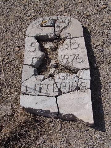
The picture you see above is of the grave of some cowboy from the 1800's, another victim of the Devil along this trail of history and death.

All in all it was a great trip for our inaugural trip. With that out of the way and everyone feeling real good about how this turned out, we were ready to start planning more trips.

New friendships and the beginning of the new Jeep Expeditions Group !

Vist the Photo Gallery for plenty of pictures of this and other Expeditions


Jeep Expeditions is the PREMIERE Jeep Exclusive Expedition/Overland Adventure CLUB Anywhere!

Jeep Expeditions is a non-profit corporation registered in the State of Arizona.  

The state recognizes us as a fraternal organization,  we prefer to say we are a club.  Our members and volunteers are dedicated to the exploration of   this great land  for the educational value, historical value,  scenic beauty, the geology, paleontology, the camaraderie of people who share the same interests and to escape the confines of civilization if only for a few days. Our organization and members adhere to the standards of "Tread Lightly" and "Leave No Trace".

Jeep Expedition Members enjoy adventures that vary in length from one day, a weekend, long weekend, week long, two weeks and like our Arctic Expedition in 2011, a full month. Don't worry, most of our trips are one day and two day trips. We are Family Friendly and we have a number of members who bring their friendly "Jeep Dogs".

Copyright © 2006 - 2023 Jeep Expeditions, Inc. All Rights Reserved.

Jeep Expeditions Group, Jeep Expeditions, Inc., Jeep Expeditions, JeepExpeditions USA, JeepExpeditions.org. JeepExpeditions.club, JeepExpeditions.com and other names we use along with domain names owned by Jeep Expeditions, Inc are all Copyrights & Trademarks held by Jeep Expeditions, Inc. d/b/a "Jeep Expeditions" We also own Copyrights and Trademarks to our logo, Trip Decals and other variations of such as shown on this website, our Facebook Page, Twitter and Instagram accounts.

Jeep Wrangler, Jeep Wrangler Unlimited, Jeep Wagoneer, Jeep Commander, Jeep Grand Cherokee, Jeep Liberty, Jeep Cherokee, Jeep Gladiator, Jeep Scrambler, Jeep CJ, Rubicon, Renegade, Laredo, Overland, SRT-8, HEMI, Rock-Trac, Command-Trac, Selec-Trac, Quadra-Trac, Quadra-Trac II, Quadra-Drive, Quadra-Drive II, SmartBeam, Jeep, the Jeep logo, and the Jeep grille are registered trademarks of FCA US LLC. Throughout this web site all the preceding marks & logos are used for identification purposes only. JEEPEXPEDITIONS.ORG is an independent web site and is not affiliated with FCA US LLC. Other trademarks and images used throughout this web site are the property of their respective owners, have no affiliation with Jeep Expeditions and are used for informational and identification purposes only.

Terms Of Use: You may not hold the owners, operators, members (or any associated parties) of the JEEPEXPEDITIONS.ORG or any other Jeep Expeditions, Inc /Jeep Expeditions Group web sites liable or financially responsible for any damages including -- but not limited to -- emotional, physical, or financial damages incurred during or after the use of this web site. Use of this web site constitutes an agreement to these Terms Of Use.