|
When I first heard about this trail it gave me
visions of the old west when, while life was simple,
it was full of danger and adventure. Being the
history buff and Jeep Freek that I am it was time
for some research about the trail and its history.
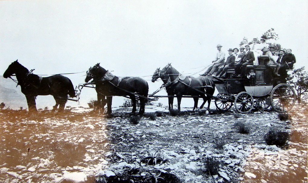
The stage line ran from 1892 to 1901 from Flagstaff
to the Grandview Hotel at the Grand Canyon. Also
called the Moqui (the original name of the Hopi
Indians) Stage Route, it was the areas mass transit
system at the time and the most popular route to the
Canyon. A six horse team covered 70 miles of trail
in just 12 hours pulling a fully loaded stage with a
trailer in tow an average 5 mph. The all day ride
cost $20 (a large sum for the time) and made three
stops to give passengers a rest and to change
horses, the final one at the Moqui Station, . An
1890s writer said, "The road is good and level with
some heavy grades. It winds among the slopes of the
San Francisco Mountains for the first 25 miles
through a fine forest of pine. The next 25 miles
lead across a rolling prairie and the rest through
the forest which skirts the rim of the Grand
Canyon. In 1901 the Grand Canyon Railroad was
completed which ultimately brought an end to the
stage line and a legend.
On this trip, members of Jeep Expeditions will spend
two days getting to the Grand Canyon with a night of
camping near the Moqui Stage Station. It appears as
if the stagecoach may have been a more efficient
form of transportation as they did the trip in 12
hours. For us it is going to be a leisurely
weekend of exploration, camaraderie, living history
and plenty of pictures.
Most of my research on the internet seemed to deal
with hiking or taking a bike on this 70 mile venture
but little or nothing about 4x4 trips. As most of
the route is on Forest Service lands my first
contact was Brian Poturalski, the Recreation Staff
Officer for the Coconino NF. Brian told me that
while he was familiar with the route and there was
some promising future plans for it, the expert was
the Kaibab NF archeologist, Neil Weintraub. Neil
told me the exciting thing about this historic trail
is that the setting has changed very little in the
108 years since the stagecoach made its last
journey. The big difference is that there are more
trees now than in the 1890s and they have taken
over some of the meadowlands. He also mentioned
that a book by Richard and Sherry Mangum called
Grand Canyon-Flagstaff Stage Coach Line was
probably the best reference resource. It is
complete with the history of the trail and had
plenty of pictures, maps and even directions. A
check with local book stores told me that the book
was out of print and unavailable. Amazon had two
in stock, I bought one!
Saturday morning, 7am, 5 Jeeps meet up at our usual
spot when heading to the high country, a McDonalds
just north of Phoenix. One thing all of us
noticed is that the old (really old) Ford truck with
the pitchfork and scythe poking up out of the bed
towards the sky that seems to be there every time we
meet was again there. Ready to roll, the drive to
Flagstaff was just about 2 hours and then another 20
minutes or so to the trail head where we will meet
up with one more of our members. At one point in
time I was talking to Jim who was nearly 50 miles
ahead of us on the ham radio. Jim told us which gas
station to fill up at where the price was 20 cents
lower than the first few that we would pass in
Flagstaff.
The drive to Flagstaff started off in the cactus
laden hills of the low desert, to the grassy high
desert plateaus and finally to the tall pines,
aspens and meadows of the high country. Our
starting elevation was about 1200 ft and our ending
elevation just over 6000 feet higher at 7500 ft.
The weather forecast mentioned a 30% of
thunderstorms. Now where we are from, a 30% chance
usually means a 0% chance but in the high country
things are different. As we exited Interstate 17 at
Flagstaff, we could tell that they had gotten some
rain that morning, at the gas station, the
attendant said it poured for an hour or more.
Despite that, the sky was more blue than gray now
and things were looking good. One thing for sure,
moisture keeps the trail dust down so breathing in
the thinner air above 7000ft will be much easier
sans dust.
At the trailhead, gray clouds hid the tops of the
San Francisco peaks. We spent 15 minutes reviewing
the maps and book again. We were off to find
the 1st of 3 way stations along the
route.
Day one was interesting. One thing we found out
quick is that the trails on our GPS werent always
there and there were trails not on our GPS that
were. To make matters worse, the trails on the
southern portion of the trail were poorly marked
making navigation by way of the directions in the
book pretty tough. It might be good to point out
that we had a number of GPS devices, Slider had a
laptop with Garmin InRoute on it using Topo 2008, I
had 5 devices set up (I have yet to find the perfect
solution but I am getting close and until then
.), a
Garmin 2610 (Topo 2008), Garmin 7200 (Topo 2008),
Toughbook Laptop with Delorme Topo 7, a Delorme
PN40SE and my newest addition the Acer Aspire 1
Netbook using National Geographic Topo for Arizona.
With all the technology, we still found ourselves
at dead ends that should not have been there and
numerous corrections to our planned route. I
should point out that after the trip, I talked to
Garmin, National Geographic and Delorme about the
software. Garmin told me that they didnt update
Topo software that often because things rarely
change. National Geographic still sells the same
software made in 2002. Delorme has just updated to
Topo 8 and while it may or may not have updated
information for the area we were on, they seem to
update quite often. In addition, Delorme allows
you to download USGS Topo quads and aerial images
for many areas to integrate with their program which
thinking back, I should have done.
As we left the pavement at the staging area and hit
the trail we were greeted by tall, ponderosa pine
and aspen trees. Wild flowers with both scattered
and concentrated to form a colorful carpet on the
forest floor. All of this fragile magnificence for
us to enjoy as Mother Natures guests for the weekend
but also to respect and protect. We could see in
some areas how a careless traveler (hiker, biker,
equestrian or Jeeper) or perhaps a random lightening
strike caused great damage and long term scarring.
It made me realize even more how venerable our
forests are to both naturally caused fires and those
caused by the carelessness of man.
Before long we had gone about 1/3 of the way and
were entering the meadowlands and now realized that
we must have missed the 1st way station.
Ok, so we have to come back again in the future and
spend more time on looking for these and less time
trying to keep on schedule. Despite our being
unable to find our 1st historic landmark, we did
find that the forests were full of deer, squirrels
and other wildlife which made for interesting
viewing. Crossing the vast grasslands, we were
now seeing many wild horses and hundreds of free
ranging cattle. On several occasions the cows
blocked the trail and looked as us as to say we
found some sweet grass so dont expect us to
move. I had the cure for that, a set of 4 train
horns powered by 150lbs of air pressure! Even
with a short blast of the horns, they only slowly
moved away, standing by the trail and looking at us
with that how dare you look.
While driving the trail today, one could only
imagine being at the reins of the stagecoach as it
made its way through field and forest. I even
felt myself at the trip leader slipping away 115
years and feeling the pounding of the hooves, the
noise of the creaky stagecoach, the dust swirling
in the air as I shake the reins and yell yeaww to
the six horse team. As we passed by places with
names like Missouri Bill Hill, Tub Ranch, Rat Tank,
Deadman Wash, Victory Lake and Colton Crater to name
a few, one could only imagine how and why some of
these names came to pass.
Well into the meadowlands, we came to a fork in the
road, seeing no signs and as the GPS showed that
either way ended up at the same place about 2 miles
ahead we chose the left fork which actually was
straight. What we did not know was that while the
fork we took might have been the trail shown in the
book at one time, it no longer was and we were
greeted first by a beware of dog sign and then
about a quarter mile later a pack of dogs. Yes a
pack, there were at least seven and they did not
seem friendly. As we slowly and carefully made
our way thru the dogs we came upon a house where a
woman came out and politely told us that we were on
private property and this road was no longer part of
the trail. She explained that a couple of years
ago a careless driver ran over and killed one of her
dogs so she no longer allows vehicles to cross her
property. No problem I apologized for the
intrusion and we made a u-turn and headed back the
other way. I made you think how one careless act
by someone can limit or close access to trails that
we have used for countless years.
By now we had passed thru Tub Ranch and were
crossing the famous Babbit Ranch where they round up
horses and auction them off annually. As we
continued the flat land gave way to more hilly
ground. Along the way noticed a carcass and even a
skeleton or two of cows that perhaps wandered too
far from their water supply or even too far from the
protection of the herd. The trail seemed to tell us
that the smallest mistake can make you a victim,
good advice to heed.
Its late afternoon and we had conquered nearly 40
miles by now. It was obvious that we somehow
missed the 2nd stop of the stage route.
Understand that the book tells us that the 1st
two stops are not marked as of yet and are just
beyond the trail that we now ride on. In the
defense of our technology laden rigs, a good portion
of the old stagecoach trail parallels the modern
trail. There are only a few sections where we
actually ride on the old trail it seems. The
Forest Service is in the process of inventorying the
trail to identify original tracks of the stage and
preserve them for years to come. We certainly
welcome what the Forest Service is doing and our
club, JeepExpeditions.org has offered to help the
Forest Service in whatever way we can in the way of
trail inventory, trail sign placement, interpretive
sign placement, etc.
As we travel on the meadows start to fade away and
scruffy pine trees begin to appear and start turning
the landscape again to a kind of forest. The GPS
tells me that we are only a mile from the 3rd
and final stop of the old stage route, the Moqui
Station. Just down the road a sign on our right
welcomes us to the Moqui Stage Stop. There is a
good amount of room to park but not much left of the
old station to look at. We find some evidence of a
foundation or two and what is left of a cistern at
the sight. There is evidence that people have
camped there recently as we found a couple of fire
rings. While this would have made a nice place to
set up for the night, Neil, the archeologist asked
us not to make camp at the historic site as there
were plenty of larger areas within a half mile of
the Moqui Stop. And yes there were plenty of other
places to camp, we had passed on about a quarter
mile back and that is where we went to set up our
Saturday night camp.
The Saturday camp site was a nice flat area that had
a large open area for a central campfire and lots of
scruffy pines scattered around providing both some
shade and a break from the winds. I attracted some
attention with a new tent that I bought recently
that sets up pretty much in about a minute or so by
one person. It looks like any real tent with
poles and such but it is made by a company called 1st
Up who also makes those quick, wall less sun tents
you see at outdoor events. Robert, one of our new
members, was working on the roof top tent that was
on top of his new JK. Even though my new tent went
up quick and easy, I was missing my roof top tent
as I decided to leave my trailer at home for this
trip.
Within about 20 minutes or so you could smell dinner
cooking and Slider was over at the fire ring setting
up for the evening campfire. My dinner was going
slow, the mini charcoal grill with the instant
light charcoal wasnt lighting too well. I was
thinking an ounce or two of gas but my sane side
took over and I just kept at it with my strike
anywhere matches. The good news was that my
butane stove made quick work of the pre-cooked baked
potato and buttered corn that I had vacuum frozen
earlier in the week. I think everyone else had
eaten as Jeepers with chairs and malt beverages
began circling the fire ring and my chicken breasts
were still raw.
Slider and B-Rad had a great fire going, possibly a
record one as far as our group goes. We brought
our own and there was plenty of dead Pinon Pines
laying around for the gathering. My dinner finally
done and gulped down I join the group at the fire.
Hey, who forgot the SMORES? Not even a
marshmallow. Guess I will take the blame as it is
me who usually brings those delicacies. Anyway,
the fire side at a Jeep Expeditions outing is always
interesting. Of course we talk about what we did
and saw that day and what the plan is for the next
but you also get some history, some tech and even
the usual Jeep tall tales. It was obvious that
everyone enjoyed the days adventure and were excited
about what was in store for day two.
Going on about midnight, half of the group had
already turned in for the night and the other half
was still at the fire. The cracking and dancing
flames seemed to be telling us that we had enough
wood on it to last half the night. I think we
used 10 gallons of water to douse it so we could get
some sleep for the big day ahead.
I dont know if it is anticipation, the clean air,
the sound of the birds singing their morning songs
or even the bright sun rising to the east, but I can
never seem to sleep past 6am when camping. Today
was no different. As I exited my tent there were a
few people stirring and still some snoring going on
in some tents. The sun had already cleared the
horizon and had a warm glow to it. The sky was
blue, the temps were very nice and foretold a great
day ahead of us. Over the next two hours the happy
campers made breakfast and packed away their gear so
that we could hit the trail by 8am. As we left
our stop for the night we knew that one day we would
camp there again.
Back to the Moqui station. More group photos and
more exploring the site. One of the group found
the skull of what appeared to be a small predator.
It had some impressive teeth that said carnivore
and we wondered what it might be. We lined up the
Jeeps for a few group shots with and without their
crews. After that it was time to hit the trail
again.
How different the landscape changes over the course
of 20 or so miles. We are now back in to a mixture
of large grassy areas, tall pines, some scrub
brush and more evidence of forest fires. As I lead
the group down the trail I again have visions of
driving the stage back in 1900 as my Jeep bounced
and creaked on the trail. It was a good feeling
and I felt as if I could have been there way back
when. With every mile I was reminded of the
statement the Forest Service Archeologist said the
neat thing is that the trail has changed very little
in the last 100+ years.
Next stop, Grand Canyon National Park. The sign
on the trail greeted us as we crossed the cattle
guard into the park. A very short distance into
the park we arrived at the Grand View Fire Tower.
This was a piece of history and time for a stop to
do more exploring.
The 80ft - Grandview Lookout Tower is a fire lookout
tower built by the Civilian Conservation Corps in
1936. There was a bit of a wind blowing and those
who were brave enough to climb to the top said they
could feel the tower swaying in the wind.
At the top of the tower you can get some great views
of the Grand Canyon Rim and the Coconino. The
interpretive signs told us the history of the tower
and fire towers in general in our National Forests
and area information and history. As a
convenience, there were some real facilities here,
the first since we hit the trail.
We hit the trail again heading for Grandview Point,
a popular stop at the south rim of the canyon. At
7406 feet, Grandview point is one of the highest
points on the south rim. As we left the dirt trail
for the pavement, we had about 2 miles to the
point. The road was lined with a thick wall of
pines and the air was sweet with the pine scent.
As we made the turn to Grandview Point, it was
evident as to just how popular it was. The parking
to the east as you entered was completely full.
Fortunately the west lot (which we could not see due
to the trees) had enough spots for the group.
Walking to the gateway we noticed tourists from
all corners of the world. I heard German, French,
Japanese, Chinese, Spanish and even some of the
Kings and Australian English. Everyone was taking
pictures and video. The canyon below to the east,
west and north was nothing less than impressive.
Although I had been there a few times before, I
continued to feed the memory card in my camera with
image after image. The north rim, many miles away
loomed about 1000 or so feet higher. Looking over
the landscape one could not begin to imaging the
power of the Colorado River and the time it took
nature to carve out this natural wonder of the
world. One thing about the Grand Canyon, like the
Foreigner song, it feels like the first time, every
time and this time was no different.
There were plenty of interpretive signs that told us
of the old stage line that brought tourist there,
you know the one we had been shadowing for the last
day and a half. The mining below, the old Grandview
Hotel where the tourists spent their time after
being brought there on the stage and how it all
ended shortly after the railroad had been completed
twelve miles to the west. Some tourists were
trying out at least part of the Grandview Trail but
it is safe to assume that few of them ventured more
than a few hundred yards. The pictures of the
trail were enough to keep me up top, just looking at
the pictures of parts of the trail were enough to
give you pucker factor.
With everyone ready to roll again we backtracked to
the fire tower and continued on the trail out of the
park. Shortly after entering the Forest Service
lands again we turned on FR310, the Coconino Rim
Trail which would take us south east. This trail
had a few rough spots on it but nothing our Jeeps
could not handle. One of the signs we saw said
that there were some great views of the Painted
Desert from the trail but try as we might, every
left turn we made in search of the rim and the
promised views turned into a dead end. At one of
those dead ends we spotted the carcass of an elk
hanging over a tree branch. It gave me visions of
Jason and the Golden Fleece (Jason and the
Argonauts), a movie from my early years. A few
feet away we found parts of the skeleton, minus the
front quarters, hind quarters and the head. It
sure looked like the work of poachers.
Driving down the trail, I wondered if any stagecoach
had gone this way in days past. As we hit some
areas with washouts and rocks I came to the
conclusion probably not and as far as driving it
goes, this trail was pretty fun! Eventually the
trail smoothed out a bit and we came upon a large
flat area of stone that made the perfect lunch stop.
Lunch on the trail is always interesting when some
of our beloved dogs travel with us. My Cassie
stayed home for this trip but Jim brought Baron,
you know the huge Rottweiler. Baron is always the
gentle one when it comes to food. Always wanting
to let him know that you are family, I fed him
some Swiss cheese and Black Forest Ham. Baron like
any pet dog can be a beggar if you tempt him and his
smile when he would like to share your lunch is
irresistible. Now with lunch over the interesting
part happens. It is time for Baron to get in the
Jeep. Step 1: Jim lifts Barons front legs onto
the seat of the lifted TJ with 35s. Step 2: Jim
wraps his arms around Barons belly and lifts him up
into the Jeep. Step 3: Baron growls with his
dislike of being manhandled. Step 4: Jim is lucky
if Baron doesnt take a bite out of Jim! This
time, no bite.
Watching our GPS units as we continue down Coconino
Rim Trail we watch carefully for our next turn.
Our goal here is to intersect with Gray Mountain
Trail which takes us south, parallel to Route 89 and
back to Flagstaff. While not rocket science, it
sometimes is a challenge and even tricky with trails
on the topo maps that arent on the trail. The
next 45 minutes brought us to the end of the trail
and the intersection of the Gray Mtn. Trail.
There are some great views of some deep and narrow
canyons running to the north here. The area is now
more of a grass land with few trees. It should be
noted that this trail is entirely on the Navajo
Nation Reservation. The trail began as many other
trails we had been on, rather tame but full of
scenery and photo opportunities. We passed many a
wild Indian ponies roaming the grassy meadows and
many cattle free ranging. About half way down the
trail we were stopped by a pick up truck with a huge
tank of water on the back. It was a Navajo rancher
and he wanted to make sure that we knew were on
tribal lands. As I talked with him he gave me a
lesson of how sacred the land is to them and asked
us to be sure to respect it. I told him that we
would do nothing less and we were grateful to be
able to drive this trail across their land. He
told us that we were in store for some great driving
ahead when we hit the switchbacks that would take us
from 8000 feet to about 5000 feet.
It wasnt long and the prophecy came true, the
switchbacks were just in front of us. And we were
in store for some excellent views of the Painted
Desert, impressive canyons, the San Francisco
Peaks to the south and the volcanic highlands all
across the southern horizon. This was one of the
best driving parts of the trail. Most switchbacks
arent much of a challenge and this one was no
different. I was however fun to drive and made you
pay close attention to the road. The one thing
that switchbacks do afford you is the opportunity to
take pictures of the Jeeps in front of you as they
go down (in my case as trip leader none) and the
Jeeps behind you coming down. I took advantage of
the opportunity and took numerous pictures of
everyone in our group. While it seemed to take
forever to get down to the 5000 ft level, we finally
got there. The landscape was more barren here as
they get more rain in the higher elevations. A
huge man made lake to our left was being used by
scores of cattle drinking and cooling off their
hooves in the water.
It was just about 8 more miles until we hit pavement
and the closer we got to the town of Gray Mountain
the more signs of civilization we passed. Lots
of homes, many of them with solar panels as there
was no electricity this far out, all of them with
outhouses and some of them with traditional Navajo
Hogans next to their homes. It was obvious that
most of the inhabitants were ranchers of sort and
many a driveway was home to pick up trucks and horse
trailers. Lots of them had horse corrals and
stacks of hay and to my surprise almost all of them
had Dish Network dishes on the side of their
homes. Closer to town we ran into small and large
groups of sheep in the road and along the side
looking for the sweet grass.
All trips have to come to an end eventually and this
one is no different. We arrived at the town of
Gray Mountain with its souvenir shops, gas station,
abandoned hotel and the local eatery. We stopped
to air up our tires before hitting the pavement and
the 2-3 hour ride home, or in Curlys case 6
hours. As the Jeeps were airing up we gathered
around and talked about how enjoyable the whole trip
was. When I mentioned about doing it again and
spending more time looking for the first two stage
stops, pretty much everyone said they were in for
an encore. With that we said our goodbyes until the
next time and began the trip home.
The Flagstaff to Grand Canyon Stage Route Photo
Gallery - CLICK HERE
Jeep Expeditions Photo Gallery - CLICK HERE
|