
IMPORTANT NOTICE!
Activities and vehicle modifications appearing, described, recommended, or linked to on this web site may be potentially dangerous.
We do not endorse any such activity for others or recommend it to any particular person.
These are simply the experiences and opinions of the writers.
If you choose to engage in these activities it is by your own free will and at your own risk.
Any and all modifications will likely cause a vehicle to behave differently than stock - some modifications may significantly increase your risk for an accident
or equipment failure when driving the vehicle or be dangerous in some driving situations.
Use common sense when engaging in any activity or making any modifications.
Do not take unwise risks, consult a certified professional if you are not sure of something, if you are uncomfortable with your mechanical ability, if you don't
have the experience to do a project, if you have not received proper training and education for the job you are thinking about doing, or if you do not have the proper tools, equipment or safety devices to do the job you are considering.
The owners, operators, members (or any associated parties) of the JEEPEXPEDITIONS.ORG web site and the writers / authors of the content contained within this web
site are not liable or financially responsible for any damages including -- but not limited to -- emotional, physical, or financial damages incurred during or after
the use of this web site or any content contain within.
|

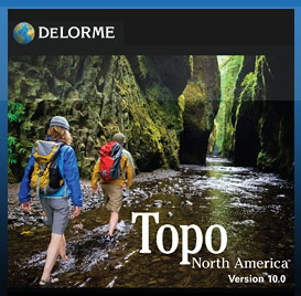
Equipment Reviews: DELORME TOPO 10 NORTH AMERICA
This is what Delorme says about it:
DELORME TOPO 10 now including CANADA!
The Latest Terrain, Road, and GPS Maps for Confident Planning and Navigation, Every Time
Scout your destination as if you were there, with up-to-date terrain, trail, and road detail. Fly over realistic 3-D. Import
aerial imagery. Route your travels over roads and trails. Find public recreation lands. See elevation profiles. Customize and
print maps at a wide range of scales. Then, navigate worry-free in your vehicle, on foot, or on the water, anywhere from the Yukon to the Rio Grande.
- US & Canada Topographic & Street Maps
- Major roads for Mexico
- Over 4 million places-of-interest (POIs) in the U.S. and Canada
- Exclusive & Extensive U.S. trails network and public lands, including BLM
- Share your Custom Maps Online
- Color Aerial imagery options, NOAA nautical charts & millions of points-of-interest
- Unrivaled GPS capabilites. Improved photo-tagging, flyovers, and tools for fitness monitoring
- Road and trail data in the US and Canada including more than 800,000 new road names in the US
- High-detail lake, river and stream data for all 50 states
- Now includes park data in Canada, 38 National Parks and 100 popular Provincial Parks
- Updated elevation data for Alaska
- See DeLorme Atlas & Gazetteer locations and descriptions in Topo North America
- Flexible Printing Options
Here Is What WE Say About It
I have personally used Delorme software probably since the mid 1990's with a lap top and a GPS receiver. Like clockwork, every year I would buy
the newest version every year of "Streets" software and found that it was a great tool to have in my vehicle. I've learned not only with Delorme but
all of its competitors that information on new streets and such are a few years behind each new version. You almost have to get the new Streets software each year
to keep up with new roads and addresses. Like I stated, all GPS software issuers have the same problems with their Streets software so it's not a big
issue.
But, we aren't talking about Streets, we're talking Topo, and unlike the competition, Delorme Topo also has detailed street information, POIs and routing built into it.
Where as
mountains and streams and for the most part forest roads and trails pretty much don't change (they shouldn't as you cannot make new trails on public lands
and many existing trails end up being closed by the government each year) the info in Streets does. Yet I don't think that it is necessary to upgrade your
Topo software when a new version comes out. Hovever, when it comes to version 10, if you have Version 9 or older, then by all means you should upgrade
to not only update the newest street information but also to get Canadian coverage.
When Delorme came out with GPS units and Topo software, I don't quite remember. What I do know is I have been using Delorme Topo software since approximately
the mid-2000's. I might add that I have also used National Geographic Topo and Garmin Topo too and all of them have some features that the other does not.
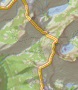
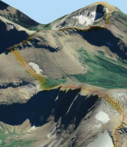
Topo creates a bright and faily detailed picture on your PC's screen. The 3D imagery is crisp and impressive and you have the option of having a split screen
with 3D on one side and 2D on the other.
It interfaces very well with a Delorme hand held GPS and their GPS units sync very nicely with a laptop via a USB connection. You can import GPX files created on
other devices (Garmin, etc) and other software (Garmin, National Geographic Topo, etc.).
My biggest complaints with Delorme Topo? It is not very user friendly and takes a while to get used to. In the beginning it is like one of the new video games
which have all kinds of secret codes and way too many options for me to be comfortable with. Routing off-road has its challenges. It is missing trail info
(to be fair, all of the rest of the competition also is missing some trails and trail info) and
therefore has difficulty routing a small percentage of trails correctly between waypoints. What you end up when that happens is a straight line from point A to
point B. It does
route just fine on well defined major trails and most streets. If you do have a set of good consistant tracks and import them to the Delorme program you can
create a route that follows the line with the click of your mouse, a very nice feature. Yet, despite Delorme Topo's short comings, I continue to use it on a
fairly regular basis with my computer in planning off-road trips..
Other complaints is that the drawing feature as a few bugs and Delorme seems to know about it, at least according to some Blogs. The user interface hasn't changed
much if any over the last few
versions so there doesn't seem to be any rush to fix the user friendly problem. Then there is the problem that all Topo software seems to have are trails or small
sections of trails that are
missing and don't show up and trails that show up that aren't really there. Which is why you need to have paper maps with you too if you want to be prepared
Customre service is "iffy" and online help whenever I tried to use it was a joke. Oh one more drawback, that all of the competitors have too is that Mexico is
major roads only. If you need very accurate maps with Topo for Mexico you need to check out Mexico Maps online.
My suggestion to everyone when you buy your new Topo 10 is to buy a map subscription from Delorme. With that you can download some very nice color aerial
imagery and US 1:24,000 Topo Quads to enhance
your maps. The map subscription price is very reasonable, under $30 a year. This is the BIGGEST advantage that Delorme has over all the others.
You can be looking at an actual picture
of the area showing trails that might not be on the map itself. You can also download USGS Topo Quads! As far as I know there is no other GPS program out there
from the major players (Garmin, Magellen and such) that offer this type of upgrade for so little cost or at any cost.
Bottom line? Buy the software for use on your laptop, it's a good program with a nice look. Buy the subscription and enhance the maps. Delorme software, like
Garmins does not work with GPS units other than Delorme units but it does work very nicely on your home PC, laptop or Netbook. Finally, get used to frustration
until you get even a little used to working with the program as it
is difficult and not very user friendly. All in all, I will continue to upgrade from time to time as it does have some good points and who knows, maybe some
of the bugs will finally get fixed and they will make it so easy to use that "a caveman can do it"!

If you sign up to receive emails and special offers on the Delorme site, they will tell you when a new product releases or a sale is going on. I look forward to
getting their emails which won't drive you crazy with weekly messages.
It's easy to miss but if
you scroll down their home page to just above the "footer" of the page you will find a place to put your email address on the left side.
Click here to order -------> Delorme Topo 10
|
 |
Want to have YOUR Product Reviewed Here?
If you have a quality product that can be used by the off-road pubic we would be glad to test it, do a fair write up about it
and make an honest recommendation about it.
Products that we feel are useful to off-road travel whether it be Jeep related or camping related will not only be posted on our website but we will submit them
to one of several magazines for more possible exposure.
Email info@jeepexpeditions.org with detailed information about your product and your interest in working with
our organization.
------------------------------------------------------------------------------------------------------------------------------------------------------
*The opinions expressed in this product review are the opinions of the writer and are based on the writers tastes and preferences. The writer
may have and in most cases invited other people to participate in this review. Despite the review (favorable/unfavorable)
you are encouraged to try out any product that you might be interested in.
**Copyrighted images & trademarks for products/items appearing on this website and/or portrayed and reviewed here
are the property of their respective owners
and are used within for informative and identification purposes only.
|
|
Jeep Expeditions is the PREMIERE Jeep Exclusive Expedition/Overland Adventure CLUB Anywhere!
Jeep Expeditions is a non-profit corporation registered in the State of Arizona.
The state recognizes us as a fraternal
organization, we prefer to say we are a club. Our members and volunteers are dedicated to the exploration of
this great land for the educational value, historical value, scenic beauty, the geology, paleontology, the camaraderie of people
who share the same interests and to escape the confines of civilization if only for a few days. Our organization and members adhere to the
standards of "Tread Lightly" and "Leave No Trace".
Jeep Expedition Members enjoy adventures that vary in length from one day, a weekend, long weekend, week long, two weeks and like our Arctic
Expedition in 2025, Forty Five Days! Don't worry, most of our trips are one day and two day trips. We are Family Friendly and we have
a number of members who bring their friendly "Jeep Dogs".
Copyright © 2006 - 2025 Jeep Expeditions, Inc. All Rights Reserved.
Jeep Expeditions Group, Jeep Expeditions, Inc., Jeep Expeditions, JeepExpeditions USA, JeepExpeditions.org. JeepExpeditions.club,
JeepExpeditions.com and other names we use along with domain names owned by Jeep Expeditions, Inc are all Copyrights & Trademarks held by
Jeep Expeditions, Inc. d/b/a "Jeep Expeditions" We also own Copyrights and Trademarks to our logo, Trip Decals and other variations of such as shown
on this website, our Facebook Page, Twitter and Instagram accounts.
Jeep Wrangler, Jeep Wrangler Unlimited, Jeep Wagoneer, Jeep Commander, Jeep Grand Cherokee, Jeep Liberty, Jeep Cherokee, Jeep Gladiator,
Jeep Scrambler, Jeep CJ, Rubicon, Renegade, Laredo, Overland, SRT-8, HEMI, Rock-Trac, Command-Trac, Selec-Trac, Quadra-Trac, Quadra-Trac II,
Quadra-Drive, Quadra-Drive II, SmartBeam, Jeep, the Jeep logo, and the Jeep grille are registered trademarks of FCA US LLC. Throughout this
web site all the preceding marks & logos are used for identification purposes only. JEEPEXPEDITIONS.ORG is an independent web site and is not
affiliated with FCA US LLC. Other trademarks and images used throughout this web site are the property of their respective owners, have no affiliation with
Jeep Expeditions and are used for informational and identification purposes only.
Terms Of Use: You may not hold the owners, operators, members (or any associated parties) of the
JEEPEXPEDITIONS.ORG or any other Jeep Expeditions, Inc /Jeep Expeditions Group web sites liable or financially responsible for any damages
including -- but not limited to -- emotional, physical, or financial damages incurred during or after the use of this web site. Use of this
web site constitutes an agreement to these Terms Of Use.
|
| |