
IMPORTANT NOTICE!
Activities and vehicle modifications appearing, described, recommended, or linked to on this web site may be potentially dangerous.
We do not endorse any such activity for others or recommend it to any particular person.
These are simply the experiences and opinions of the writers.
If you choose to engage in these activities it is by your own free will and at your own risk.
Any and all modifications will likely cause a vehicle to behave differently than stock - some modifications may significantly increase your risk for an accident
or equipment failure when driving the vehicle or be dangerous in some driving situations.
Use common sense when engaging in any activity or making any modifications.
Do not take unwise risks, consult a certified professional if you are not sure of something, if you are uncomfortable with your mechanical ability, if you don't
have the experience to do a project, if you have not received proper training and education for the job you are thinking about doing, or if you do not have the proper tools, equipment or safety devices to do the job you are considering.
The owners, operators, members (or any associated parties) of the JEEPEXPEDITIONS.ORG web site and the writers / authors of the content contained within this web
site are not liable or financially responsible for any damages including -- but not limited to -- emotional, physical, or financial damages incurred during or after
the use of this web site or any content contain within.
|

GARMIN GPSMAP 478 CHARTPLOTTER
Here Is What WE Say About It:
I have been using GPS for over 10 years in one form or another. More than 25 models over time from laptop applications to hand held devices to
automotive units to chartplotters. My current collection of GPS units totals 12. So what in the world do you need 12 GPS units for. You dont.
What I am seeking is the perfect unit that can do everything I expect and need a GPS to do. Is there such a beast ? Not that I have found but there
are a few that are close.
For off-roading/overland travel the typical automotive GPS sold today by most retailers just wont cut it. Sure they are great for finding the way to
that new restaurant youve heard of, to that big garage sale on Saturday and your way around towns, cities and everywhere with a paved road in between.
Unfortunately, they arent designed with the off-roader in mind. The smaller hand held units were designed for the wilderness and are great for hikers
because of their size but for vehicle navigation the screens are just too small.
Don't get me wrong there are some very nice off-road GPS designed for in vehicle navigation. One that comes to mind is the Lowrance Baja units. The big
disadvantage is that there are no Topo maps for that unit (I had a long talk with both a salesman and an engineer at Lowrance and they both lamented how their
company does not support their units with software) that compare in any way to those that Garmin (or even Delorme or Nat Geo has to offer) but none of
the really good software programs will operate on each others units. It's a way for the GPS manufacturers to force you to buy both their hardware and
software. It's a good business model for them but not for the consumer.
That takes us to Garmin Marine Chartplotters. Not all of these units are suitable for vehicle navigation . The ones that are, while not perfect, stand out in
a "sea" of GPS units. One of these units is the Garmin GPSMAP 478 and the unit that I will be using in my Jeep until something better comes along.
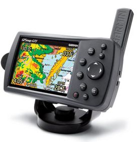
The 478 has many of the features that I feel are important for off-road use:
- A larger, sunlight readable color screen (twice the size of a hand held unit)
- NMEA 0183 output for connection to a laptop via USB
- Track Log 10,000 points, 20 saved Tracks
- 3000 saved Waypoints
- 50 saved Routes
- Portable, can run 9 hours on its lithium-ion battery
- Weather/water proof and shock resistant
- XM weather compatible
- Card slot to accept additional maps
- Sun & Moon info, Tide tables and Hunt Fish calendar
- Ability to connect to APRS enabled Ham Radios via data connection cable
- Turn by turn navigation when not off-road
With its detachable external antenna, the 478 quickly picks up satellites, even indoors. The XM weather function (you need to buy the optional
antenna and subscribe to the service) will show you right on the screen current weather conditions and systems right on the screen for the US and Canada.
While it doesnt offer an MP3 player, it does work quite well with XM Satellite Radio.
You might wonder why tide tables might be important. On a recent Jeep Expedition we drove the coastline of the Sea of Cortez from near the mouth of the
Colorado River south to near Puerto Penasco, Mexico. Without tide information we ran the chance of being either stranded for 12 hours or being swept
away by the high tide, a tide that in places comes right up against the 50+ foot vertical cliffs.
But the Track Log feature is one of the most important. Save your tracks from each trail, share tracks with friends, use tracks from popular programs
like TrekNow to navigate off-road trails. Load up to 20 tracks to your unit and follow them thru a new and unfamiliar trail or on one of your favorite
trails. Using saved tracks leaves nothing to chance and saving tracks on new adventures will help you navigate those trails again in the future.
Is 20 saved tracks enough, the answer quite simply is NO. The GPSMAP478 will store 50 routes, why not 50 or 100 tracks Garmin?
The GPSMAP 478 comes ready for the water, the road and the trail. It has pre-loaded Garmin street maps, pre-loaded coastal maps, vehicle mount,
marine mount, vehicle power cable, data cable for direct wiring (power, sound and data) and more. You will need to buy at least one Garmin Data card
to load Topo software for off-roading and if you want XM weather and/or XM Sat Radio, the GXM30 XM antenna.
How does this unit perform in the real world ? Excellent ? I have tested it off the coast of Mexico using Blue Chart maps, in the cities and
highways of Arizona and California and have used it extensively off-road. Is it perfect? No but its not too far off. So what would it take to
make this unit my perfect unit ? How about a 5 or better yet 7 touchscreen, ability to save up to 100 tracks, ability to use SD cards for
additional maps (the 478 uses Garmin Data Cards, hard to find, not much capacity (512kmax) and very expensive at $100-$250), and all the features
of a high end automotive GPS like my Nuvi 2595LMT.
The GPSMAP 478 retails new for $799. I have seen fully warranted refurbs available online for under $600 and used ones online in the $400s.
Unfortunately Garmin has since discontinued this model but you can still find new units online at a number of places. In addition, Ebay is a great
source for new and used units and all kinds of accessories.
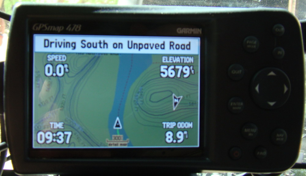
The picture was taken in Canyon De Chelly, AZ using Garmin 24K Topo maps. The trail uses the riverbed in many places which is why it looks as
if the trail is running down the center of a river.
The Garmin GPSMAP 478, its worth considering for the serious off-roader wanting more than the big box store automobile units can give you until something better
comes along. I'm still using it as 2014 comes to a close and I still haven't found a better option!
UPDATE: Sometime after doing this reveiw I acquired a Delorme PN-60w with SPOT Communitcator. It does everything that this Garmin unit does only more.
Although the screen size of the GPSMAP 478 is a bit larger than that on the PN60w, the cost of memory for use in the PN-60w is CHEAP. You can't beat the
$40 cost of a 32GB SDHC card for the Delorme PN60w. The big disadvantage for the Garmin GPSMAP 478 is the fact that additional maps can
only be used by transferring them to Garmin Data cards. Garmin Data cards are not only expensive but have a maximum size of 512mb which limits you.
For example a 256mb data card will set you back around $150. The largest 512mb cards will cost over $200 when you can find them.
Based on the cost of memory alone the Delorme PN-60w is the best choice. It is a full featured PREMIUM GPS unit that is technically superior
in my opinion to the Garmin and as a bonus has the safety, security and features of SPOT.
p.s. Someone write Delorme and ask them to make
a 5" or better yet 7" GPS for us overlanders and off-roaders.
----------------------------------------------------------------------------------------------------------------------------------------
|
 |
Want to have YOUR Product Reviewed Here?
If you have a quality product that can be used by the off-road pubic we would be glad to test it, do a fair write up about it
and make an honest recommendation about it.
Products that we feel are useful to off-road travel whether it be Jeep related or camping related will not only be posted on our website but we will submit them
to one of several magazines for more possible exposure.
Email info@jeepexpeditions.org with detailed information about your product and your interest in working with
our organization.
------------------------------------------------------------------------------------------------------------------------------------------------------
*The opinions expressed in this product review are the opinions of the writer and are based on the writers tastes and preferences. The writer
may have and in most cases invited other people to participate in this review. Despite the review (favorable/unfavorable)
you are encouraged to try out any product that you might be interested in.
**Copyrighted images & trademarks for products/items appearing on this website and/or portrayed and reviewed here
are the property of their respective owners
and are used within for informative and identification purposes only.
|
|
Jeep Expeditions is the PREMIERE Jeep Exclusive Expedition/Overland Adventure CLUB Anywhere!
Jeep Expeditions is a non-profit corporation registered in the State of Arizona.
The state recognizes us as a fraternal
organization, we prefer to say we are a club. Our members and volunteers are dedicated to the exploration of
this great land for the educational value, historical value, scenic beauty, the geology, paleontology, the camaraderie of people
who share the same interests and to escape the confines of civilization if only for a few days. Our organization and members adhere to the
standards of "Tread Lightly" and "Leave No Trace".
Jeep Expedition Members enjoy adventures that vary in length from one day, a weekend, long weekend, week long, two weeks and like our Arctic
Expedition in 2025, Forty Five Days! Don't worry, most of our trips are one day and two day trips. We are Family Friendly and we have
a number of members who bring their friendly "Jeep Dogs".
Copyright © 2006 - 2025 Jeep Expeditions, Inc. All Rights Reserved.
Jeep Expeditions Group, Jeep Expeditions, Inc., Jeep Expeditions, JeepExpeditions USA, JeepExpeditions.org. JeepExpeditions.club,
JeepExpeditions.com and other names we use along with domain names owned by Jeep Expeditions, Inc are all Copyrights & Trademarks held by
Jeep Expeditions, Inc. d/b/a "Jeep Expeditions" We also own Copyrights and Trademarks to our logo, Trip Decals and other variations of such as shown
on this website, our Facebook Page, Twitter and Instagram accounts.
Jeep Wrangler, Jeep Wrangler Unlimited, Jeep Wagoneer, Jeep Commander, Jeep Grand Cherokee, Jeep Liberty, Jeep Cherokee, Jeep Gladiator,
Jeep Scrambler, Jeep CJ, Rubicon, Renegade, Laredo, Overland, SRT-8, HEMI, Rock-Trac, Command-Trac, Selec-Trac, Quadra-Trac, Quadra-Trac II,
Quadra-Drive, Quadra-Drive II, SmartBeam, Jeep, the Jeep logo, and the Jeep grille are registered trademarks of FCA US LLC. Throughout this
web site all the preceding marks & logos are used for identification purposes only. JEEPEXPEDITIONS.ORG is an independent web site and is not
affiliated with FCA US LLC. Other trademarks and images used throughout this web site are the property of their respective owners, have no affiliation with
Jeep Expeditions and are used for informational and identification purposes only.
Terms Of Use: You may not hold the owners, operators, members (or any associated parties) of the
JEEPEXPEDITIONS.ORG or any other Jeep Expeditions, Inc /Jeep Expeditions Group web sites liable or financially responsible for any damages
including -- but not limited to -- emotional, physical, or financial damages incurred during or after the use of this web site. Use of this
web site constitutes an agreement to these Terms Of Use.
|
| |