
IMPORTANT NOTICE!
Activities and vehicle modifications appearing, described, recommended, or linked to on this web site may be potentially dangerous.
We do not endorse any such activity for others or recommend it to any particular person.
These are simply the experiences and opinions of the writers.
If you choose to engage in these activities it is by your own free will and at your own risk.
Any and all modifications will likely cause a vehicle to behave differently than stock - some modifications may significantly increase your risk for an accident
or equipment failure when driving the vehicle or be dangerous in some driving situations.
Use common sense when engaging in any activity or making any modifications.
Do not take unwise risks, consult a certified professional if you are not sure of something, if you are uncomfortable with your mechanical ability, if you don't
have the experience to do a project, if you have not received proper training and education for the job you are thinking about doing, or if you do not have the proper tools, equipment or safety devices to do the job you are considering.
The owners, operators, members (or any associated parties) of the JEEPEXPEDITIONS.ORG web site and the writers / authors of the content contained within this web
site are not liable or financially responsible for any damages including -- but not limited to -- emotional, physical, or financial damages incurred during or after
the use of this web site or any content contain within.
|

Equipment Reviews: GARMIN TOPO CANADA
This is what THEY say about it:
We've mapped every hill and valley for your next great adventure. This map covers the finer
details of the outdoors, including terrain contours, topo elevations, summits, routable roads
and trails, rivers, lakes and geographical points.
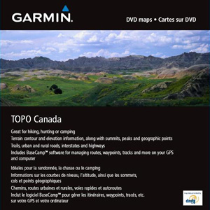
- Provides detailed topographic maps, based on digital 1:250,000 and 1:50,000 scale NTS data.
- Contains hydrographic features, including coastlines, lake/river shorelines, wetlands and perennial and seasonal streams.
- Includes searchable points of interest, such as parks, campgrounds, scenic lookouts and picnic sites.
- Offers terrain contour and elevation information, along with summits, peaks and geographic points.
- Contains routable roads, trails and highways in metropolitan and rural areas so getting to your destination is easy.
- Displays national, state, local parks, forests and wilderness areas.
- Available in DVD and microSD/SD Card formats
- Includes BaseCamp software (DVD Only) for managing data on your GPS and computer, playing back routes and tracks, geotagging photos and more
Here Is What WE Say About It
Going to Canada? You can buy the entire country on a DVD or buy regions on SD cards. Let me make your decision easy, buy the DVD because you are going to need
at least two regions for any big trip to Canada and for about the price of two SD cards, you can buy the DVD of the entire country.
In 2011 Jeep Expeditions undertook the nearly 11,000 mile round trip from Arizona to Alaska with lots of time in Western Canada. From the Icefields Parkway to Jasper,
Banif, Lake Louise, Whitehorse, Dawson & Dawson City and as far up as Inuvik, at the end of road. I planned our routes with Garmin Topo Canada v2.0 which was to
say a bit of a disappointment. With luck before the trip I got my hands on Garmin Topo Canada 4. Instead of several CDs covering regions and disappointing features
like v2, the new v4 was a welcomed addition to my library of GPS software!
Topo maps are what we use on the trail and for the most part, Garmin Topo Canada can replace both "streets" and topo software in your compatible devices. Now unfortunately,
Garmin like most other manufacturers have their software and devices configured so that you cannot use a competitors software on their devices and vice versa. While
it's a good business plan for them, it's not the best for consumers as there seems to be some features on one program that aren't available on another. Like I have
said many times, GPS software and devices are not all created equal. In the case of Garmin Topo Canada v4, it has lots going on making it a pretty good choice and the
best
choice of software from Garmin for Canada especially if you are going to explore areas on and/or off the beaten path .
I used Garmin Topo Canada on two GPS units in my Jeep for this trip, a Garmin Nuvi 1490 and my Garmin GPSMAP 478. From the famous 500 miles of the dirt road called
the Dempster Highway taking us beyond the Arctic Circle to "the top of the world" to the Trans Alaska Highway and everywhere in between this software performed
excellent!
On your computer, Topo Canada is used with either MapSouce v 6.16.3 or Garmins newest offering, BaseCamp. MapSource is much more user friendly and has some features
I prefer over BaseCamp. BaseCamp is loaded with neat new features and while it takes a while to get used to (not very user friendly), is fun to play with and learn.
The day will come that I will totally abandon MapSource but that day isn't here yet. Unlike MapSource, BaseCamp prints out maps with UTMs, a nice feature.
But, MapSource has a pretty good users manual, and BaseCamp has no manual. Both will create routes and waypoints so you can plan your trip ahead of time on the
"big screen" (yep like the US Topo 24K, Topo Canada roads and trails will route just fine unlike the older versions).
Then you can send and receive maps, routes, way points and tracks to and from your
Garmin handheld GPS. For Nuvi products you can send and receive maps, routes and waypoints. Some Nuvi's have tracks you can download to MapSource or BaseCamp
but none of them are able to accept uploaded tracks. Perhaps one day Garmin with make a nice 5" or 7" GPS for your SUV that has all the features of their hand held
units. Oh, did I mention that you can buy the Birdseye subscription for aerial images to overlay on your maps just like with Topo 24K for the USA.
The look of the maps is pleasing with great color and detail. The detail doesn't quite measure up to the 1:24,000 of the US version of Topo 24K but it is still
twice as good as Topo 100K. This is due to Canadas official maps are only 1:50,000. Not a big deal, they perform and perform well which is what counts in the end.
There are some real short comings though. The POIs like hotels, restaurants and
shopping in the more rural areas are very much lacking but at the same time Garmin Street software (which I ran on a 3rd GPS on another Garmin Nuvi 1490)
had the same short comings in Canada, Alaska and even rural areas in the lower "48". I was pleased to see that every dirt, stone and washboard road we decided to
take was shown on the map along with many more. All I can say is so many trails and too little time. I've heard some people say that it was missing a lot of
hiking trails, didn't matter much to me, I Jeep, let someone else do the
leg work in the mountains if they want. And as I always say, heed this advice, no matter what GPS or software you use out on the
trail: ALWAYS carry paper maps as a backup!
My biggest complaint with Topo Canada? Nope, its not the price, I am prepared to and will pay a premium price for gear that has features I want and need. Topo
Canada v4 fits
that bill. I cannot use it in my vehicle on a laptop with a GPS receiver/antenna to see and record my trip in real time. It was something you could do with the
older version 2 with the discontinued nRoute program from Garmin but the new version is not compatible with nRoute.
The bottom line here is overall, Garmin Topo Topo Canada v4 is the BEST offering I've found for use in Canada on your Garmin GPS. Is it perfect? No it isn't.
Is it the only
program I used in Canada, no it wasn't as I also had Garmin North America street maps running on a 2nd Garmin Nuvi 1490 mainly for comparison. What I can tell you
is that you only need one GPS running Topo Canada. I really don't think you can buy better maps of Canada anywhere for your GPS.
Spending time in Canada, buy this program, plan your trip and ENJOY! You will thank me later :-)
Check out some screen shots below. The first shows the coverage. The 2nd and 3rd are in Banif, Canada showing town detail and trails in the country. The last
shot was from Inuvik, Canada. The tundra area is pretty much flat and is shown in white probably due to permafrost.


|
 |
Want to have YOUR Product Reviewed Here?
If you have a quality product that can be used by the off-road pubic we would be glad to test it, do a fair write up about it
and make an honest recommendation about it.
Products that we feel are useful to off-road travel whether it be Jeep related or camping related will not only be posted on our website but we will submit them
to one of several magazines for more possible exposure.
Email info@jeepexpeditions.org with detailed information about your product and your interest in working with
our organization.
------------------------------------------------------------------------------------------------------------------------------------------------------
*The opinions expressed in this product review are the opinions of the writer and are based on the writers tastes and preferences. The writer
may have and in most cases invited other people to participate in this review. Despite the review (favorable/unfavorable)
you are encouraged to try out any product that you might be interested in.
**Copyrighted images & trademarks for products/items appearing on this website and/or portrayed and reviewed here
are the property of their respective owners
and are used within for informative and identification purposes only.
|
|
Jeep Expeditions is the PREMIERE Jeep Exclusive Expedition/Overland Adventure CLUB Anywhere!
Jeep Expeditions is a non-profit corporation registered in the State of Arizona.
The state recognizes us as a fraternal
organization, we prefer to say we are a club. Our members and volunteers are dedicated to the exploration of
this great land for the educational value, historical value, scenic beauty, the geology, paleontology, the camaraderie of people
who share the same interests and to escape the confines of civilization if only for a few days. Our organization and members adhere to the
standards of "Tread Lightly" and "Leave No Trace".
Jeep Expedition Members enjoy adventures that vary in length from one day, a weekend, long weekend, week long, two weeks and like our Arctic
Expedition in 2025, Forty Five Days! Don't worry, most of our trips are one day and two day trips. We are Family Friendly and we have
a number of members who bring their friendly "Jeep Dogs".
Copyright © 2006 - 2025 Jeep Expeditions, Inc. All Rights Reserved.
Jeep Expeditions Group, Jeep Expeditions, Inc., Jeep Expeditions, JeepExpeditions USA, JeepExpeditions.org. JeepExpeditions.club,
JeepExpeditions.com and other names we use along with domain names owned by Jeep Expeditions, Inc are all Copyrights & Trademarks held by
Jeep Expeditions, Inc. d/b/a "Jeep Expeditions" We also own Copyrights and Trademarks to our logo, Trip Decals and other variations of such as shown
on this website, our Facebook Page, Twitter and Instagram accounts.
Jeep Wrangler, Jeep Wrangler Unlimited, Jeep Wagoneer, Jeep Commander, Jeep Grand Cherokee, Jeep Liberty, Jeep Cherokee, Jeep Gladiator,
Jeep Scrambler, Jeep CJ, Rubicon, Renegade, Laredo, Overland, SRT-8, HEMI, Rock-Trac, Command-Trac, Selec-Trac, Quadra-Trac, Quadra-Trac II,
Quadra-Drive, Quadra-Drive II, SmartBeam, Jeep, the Jeep logo, and the Jeep grille are registered trademarks of FCA US LLC. Throughout this
web site all the preceding marks & logos are used for identification purposes only. JEEPEXPEDITIONS.ORG is an independent web site and is not
affiliated with FCA US LLC. Other trademarks and images used throughout this web site are the property of their respective owners, have no affiliation with
Jeep Expeditions and are used for informational and identification purposes only.
Terms Of Use: You may not hold the owners, operators, members (or any associated parties) of the
JEEPEXPEDITIONS.ORG or any other Jeep Expeditions, Inc /Jeep Expeditions Group web sites liable or financially responsible for any damages
including -- but not limited to -- emotional, physical, or financial damages incurred during or after the use of this web site. Use of this
web site constitutes an agreement to these Terms Of Use.
|
| |