Here Is What WE Say About It:
I have been using GPS for over 10 years in one form or another. More than 25 models over time from laptop applications to hand held devices to
automotive units to chartplotters. My current collection of GPS units totals 12. So what in the world do you need 12 GPS units for. You dont.
What I am seeking is the perfect unit that can do everything I expect and need a GPS to do. Is there such a beast ? Not that I have found but there
are a few that are close.
For off-roading/overland travel the typical automotive GPS sold today by most retailers just wont cut it. Sure they are great for finding the way to
that new restaurant youve heard of, to that big garage sale on Saturday and your way around towns, cities and everywhere with a paved road in between.
Unfortunately, they arent designed with the off-roader in mind. The smaller hand held units were designed for the wilderness and are great for hikers
because of their size but for vehicle navigation the screens are just too small.
Don't get me wrong there are some very nice off-road GPS designed for in vehicle navigation. One that comes to mind is the Lowrance Baja units. The big
disadvantage is that there are no Topo maps for that unit (I had a long talk with both a salesman and an engineer at Lowrance and they both lamented how their
company does not support their units with software) that compare in any way to those that Garmin (or even Delorme or Nat Geo has to offer) but none of
the really good software programs will operate on each others units. It's a way for the GPS manufacturers to force you to buy both their hardware and
software. It's a good business model for them but not for the consumer.
Why Garmin? 99% of everyone that I know who Jeeps has a Garmin. It makes it much easier to share data such as Tracks,
Waypoints and Routes with so many people using a common platform. Garmin also makes more units for all types of applications and offers more software
for its units than any other manufacturer.
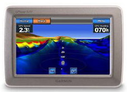
That takes us to Garmin Marine Chartplotters. Not all of these units are suitable for vehicle navigation . The ones that are, while not perfect, stand out in
a "sea" of GPS units. One of the newer units is the Garmin GPSMAP 640. It has some great features but will it have me boxing up my GPSMAP 478 and end up
full time in my Jeep? Will this be my "perfect" GPS for off-roading?
What is the perfect GPS unit? What might be perfect for me might not be perfect for you. I use GPS primarily for vehicle navigation on and off-road.
I count on 3 units for the most part. My primary GPS is a Garmin Nuvi 2595LMT, strictly an automotive unit it stays in my daily driver. For off-roading
I use several units all of them have a tracks function and larger screens than hand held units, some of them only work on 12v and are not portable.
Finally for emergencies, I carry a hand held unit in the event I would have to abandon my Jeep and start cross country by foot.
So what is my perfect GPS? Here goes:
- Ability to lay down tracks, save tracks and use saved tracks at least 50 saved tracks, preferably 100+
- NMEA 0183 output for connection to a laptop via USB
- Ability to use City Navigator, Blue Charts and Topo software
- Ability to save a fairly large number of Waypoints (1000+) and Routes (100+)
- Ability to be portable in case you need to leave your vehicle
- Card slot to accept additional maps. Able to use SDHC cards
- Weather/water proof and shock resistant
- XM weather compatible
- Something having 5 screen so it is easily readable with 7 more desirable
- Sun & Moon info, Tide tables and Hunt Fish calendar
- Ability to connect to APRS enabled Ham Radios via data connection cable
- Ability to navigate streets like most modern automotive units: Speaks street names, gives turn by turn directions, etc
- Ability to use the newer 3D Street, TOPO & Marine maps plus compatibility with older maps too.
- Touch Screen and remote control would be a great enhancement.
Will the new Garmin 640 meet my needs? It has many of the features on my wish list. Lets find out.
The new unit arrives on a Wednesday afternoon. Just in time for me to familiarize myself with how it works before I head off on a 7 day cruise to Mexico. What better chance to try out the Marine mode this unit has to offer. The new 640 comes pre-loaded with the latest Garmin G2 Blue Charts for the US. I already have standard Garmin Blue Chart software for California and Mexico which I will need to obtain unlock codes for this unit and load them onto an SD card for the trip.
Opening the box, I see that everything I would need in the form of accessories is in the box. Well almost everything. The GXM40 XM antenna is an option, a very expensive option but with it you can subscribe to XM weather and see the forecast right on the GPS from fronts moving in, temperatures, wind speeds, etc. A good feature to have on the water or in the back country. I read the manual, install the battery and proceeded to play with it and get used to its functions and features. I think I am ready for the cruise and my 1st tests.
The new 640 was used in Auto mode from Phoenix to LA for the 400 miles to the San Pedro docks where we met our ship. The pre-loaded City Navigator North America 2010 software is extremely accurate and the larger 5 screen of the 640 makes it a pleasure to use.
As soon as we board the ship I set up the GPS and laptop at the desk. Unlike in my house, the steel of the ship will not allow signals to reach my unit, the good news is I brought a Gilsen remote antenna that I mount to the balcony outside our cabin. After about 15 minutes, I have a full array of satellites and the GPS is up and running. Now I get the bad news, my Blue Chart software is not compatible with the unit so I have to rely on the built in world map which is not very detailed and once I leave US waters my view on the GPS looks more like a Google Earth image. It seems as if this unit requires the newer Blue Chart G2 software. Unfortunately it has no backwards compatibility with standard Blue Chart software.
Its not a total loss, as I connect the 640 to my laptop via a USB cable and use Garmin InRoute software to keep track of our location via my Blue Chart software. Two days into the trip at Cabo San Lucas I transfer the tracks, waypoints and route to my laptop. I am extremely pleased with the tracking, route and waypoint function of this unit in Marine mode.
The picture was taken in Canyon De Chelly, AZ using Garmin 24K Topo maps. The trail uses the riverbed in many places which is why it looks as
if the trail is running down the center of a river.
On shore I took the unit with me using Mexico GPS Atlas maps in Auto mode. Driving around the city and country side, the GPS kept track of our location and was a joy to use. If only we could have saved our tracks to transfer to the laptop but there is no tracking ability in Auto mode. My second disappointment with this unit after finding out its not compatible with my existing Blue Chart software.
During the rest of the trip the Marine mode kept excellent track of our journey on the water and was used while at shore on our travels.
Because the 640 can only use Topo software in Auto mode and Auto mode does not have any tracking functions, I wont bother testing it off-road. If you only want to look at a larger screen GPS then the 640 will work well for you with Topo software. However, you can do basically the same on any typical GPS like the much cheaper Nuvi 5000 or the Street Pilot 7200 (the 7200 will track but cannot use saved tracks) at a much lower price. But if you are like me and others, you want the tracking functions on an off-road GPS.
Pros of the GPSMAP 640:
- Uses SD cards for using additional Maps
- Touchscreen is very convenient
- 5 diagonal color screen (7 would be nicer though)
- Very readable in bright sunlight
- Water and shock resistant
- Everything you need is in the box including Auto & Marine mounts, auto cable with speaker, power and data cable for Marine use, very nice dash mount.
- The automotive mode is excellent for everyday driving, as good as it gets for an automotive unit with all of the features the average road driver would want
- XM weather compatible
- Something having 5 screen so it is easily readable with 7 more desirable
- The Marine mode for use in boating works excellent and is loaded with features
Cons of the GPSMAP 640:
- Topo must be used in Automotive mode. As such you cannot use the tracking function, you cannot save, store or used saved tracks for navigation
- Topo will NOT work in Marine mode.
- My collection of Garmin 2008.5 Blue Chart maps is not compatible with this unit. You get an error code that maps are not compatible.
The same with newer Nuvi units (functional obsolescence?).
- It seems as if the only Blue Chart maps you can use are the newer G2 Versions.
a mini plug or USB connector which you must wire and install. It is not ready to go as shipped
- FM output would be a nice feature as it is XM compatible
- An audio out jack would also be a nice feature too
My final conclusion is that the GPSMAP 640 is an excellent unit for street driving in Automotive mode and boating in Marine mode. It is NOT suitable for
off-road driving using Topo maps unless you are ok with not being able to save or use saved tracks. When I talked to Garmin, they told me that the unit was not
compatible with Topo (but it does indeed work with Topo).
Unfortunately I will sell my new GPSMAP 640 on Ebay. My hope is
that Garmin might realize that they are missing a big chunk of users and offer a software upgrade to allow the tracking functions in Marine mode to be used
in Auto mode with Garmin Topo 24K. Even then it would not have all of the options of my idea of the perfect GPS unit but it will have the most important ones.
My personal recommendation is do not buy this unit unless you need a GPS for marine navigation in your boat. It is way too expensive to use as just an automotive
GPS and just doesn't cut it as a GPS for use in your Jeep with Topo maps.
For off-roading I will continue to use my GPSMAP 478 and Delorme PN-60w mainly because they will track, save tracks and use saved tracks.
Although the screen size of the GPSMAP 478 is larger than that on the PN60, the big disadvantage is the fact that additional maps can
only used by transferring them to Garmin Data cards. Garmin Data cards are not only expensive but have a maximum size of 512mb which limits you.
For example a 256mb data card will set you back around $150. The largest 512mb cards will cost over $200 when you can find them. You can't beat the
$40 cost of a 32GB SDHC card for the Delorme PN60w. For your use, the Delorme PN-60w is probably the best choice.
Perhaps some day, someone at Garmin will read this and end up making a unit with the Overland Traveler in mind. But until then
..
----------------------------------------------------------------------------------------------------------------------------------------