|
When you hear the word Geronimo what is the 1st
thing that comes to your mind? For some it might
be the memory of childhood fun with running and
jumping into the pool in the classic cannonball
position and yelling Geronimo. But, if you are a
history buff and a fan of classic westerns it no
doubt your first thought will be of the Apache War
Chief, Geronimo.
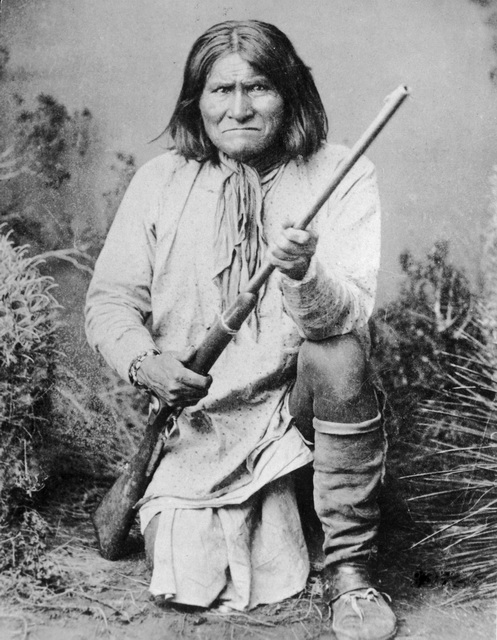
Geronimo, whose real name was Goyathlay, was born in
1829 near what is now Clifton, Arizona. At the age
of 17 he was admitted into the Council of Warriors
and soon after married and had three children. A
peaceful Apache, Geronimo became a fierce and
respected adversary of both the US and Mexican
governments after the massacre of his family by
Mexican troops while on a trading mission with old
Mexico villagers. From that day on, Geronimo
(Spanish for Jerome, the name given to him by
Mexican soldiers for reasons unknown) hated all
Mexicans.
Over the next 20 years, as the white man continued
to invade the Apache homelands, Geronimo waged
war in both Mexico and the US in the Arizona and New
Mexico territories. By the early 1870s General
George Crook managed to establish a fragile peace
and Geronimo and his followers joined his fellow
Apache in their traditional homeland.
A
few years later in 1876, the US Government uprooted
the Apaches and moved them to what is described as
Hells half acre, the San Carlos Indian
Reservation. Starving, homesick and left with few
options, Geronimo led hundreds of Apaches into
Mexico where for ten years they sporadically raided
white settlements across the border. In 1882
General George Crook was given the task of bringing
Geronimo and his followers back on the
reservation. Two years later, Geronimo and his
band of Apaches surrendered and went back to the
reservation. However , with rumors of trials and
executions for acts they had done, Geronimo again
left the reservation with about 30 warriors and 100
other Apaches to the mountains of Mexico.
Nearly one quarter of the US Army, about 5000
soldiers, took part in a campaign to bring Geronimo
and his followers back to the reservation. One
year later in Sonora, Mexico, exhausted, heavily
outnumbered and starving, Geronimo again
surrendered. As the troops escorted the rag tag
band of Apache back to Fort Bowie, Geronimo and
some of his warriors who feared they would be
executed once back at Fort Bowie bolted before they
crossed the border into Arizona.
Geronimos band of renegades numbered less than 30
and it took 1000 soldiers and six months to capture
Geronimo and his band whose final surrender took
place in Skeleton Canyon, Arizona. Geronimo and
his followers were promised they would not be tried
and would not face execution but, before they could
go back to Arizona they would have to spend time in
Florida.
Eight years later, Geronimo was moved from Florida
to Fort Sill, OK Over the next few years
Geronimo was quite the attraction at fairs where he
sold souvenirs and pictures of himself. Geronimo
was never to see his Arizona homeland and died in
1909 of pneumonia, at 89 years of age. He is
buried at the Apache cemetery at Fort Sill, OK.
In
February of 2009, the descendents of Geronimo filed
a lawsuit in Federal Court seeking the to free
Geronimo, his remains, funerary objects and spirit
from 100 years of imprisonment at Fort Sill,
Oklahoma, the Yale University campus at New Haven,
Connecticut and wherever else they may be found.
His spirit is wandering until a proper Apache
burial is performed, Harlyn Geronimo said. The
only way to put this into closure is to release the
remains, his spirit, so that he can be taken back to
his homeland in the Gila Mountains, at the head of
the Gila River, Geronimo said.
So
now that you know the rest of the story, it is my
pleasure to lead you on a trip thru time with Jeep
Expeditions on The Trails of Geronimo.
In
2008, Mike Bethel, let a group of 25 Jeeps on what
we called The Trails of Cochise. Filled with
adventure and history of the Apache warrior of the
same name, Jeep Expedition members wanted more.
Being a native of southern Arizona and a history
buff himself, Mike was more than willing to plan a
similar trip for 2008, this time following the
trails of Geronimo.
Our journey started on a Friday morning in
October. This years group of 28 Jeepers met in
Phoenix and began their travel thru time. The
road took us thru Tucson, Benson and many historic
towns in-between. After a few stops we arrived in
the famous mining town of Bisbee, AZ. Bisbee is
a quiet town with a nostalgic look and lots of
charm. If it werent for all the cars, one could
easily believe that they were standing in the same
Bisbee of the late 1800s. Little seems to have
changed other than paved streets and modern
conveniences. With some time to spare before we
hit our Friday night base camp, we did a Jeep
caravan from one end of town to the other. With
steering wheel in one hand and my camera in the
other I quickly filled up a memory card. There is
certainly lots to do and see in Bisbee but that is
for another trip in November and the group heads to
the Double Adobe Campground to set up camp and relax
for the rest of the day.
Unlike most of our trips that take place in Arizona,
the forecast was for a 40% chance of rain. Now a
40% chance of rain in Phoenix is usually laughed at
but in SE Arizona a 40% forecast should not be taken
lightly. As things would have it, I woke up in
the wee hours of the morning to the sound of a
steady rain hitting my tent. So did others. By 6
am, the rain had become an off again, on again
drizzle. We tried to quickly pack up during the
dry spell. For this trip I installed a roof rack on
the TJ to carry lighter items such as sleeping bags,
blankets, pillows, air mattress and tent on the
roof, most of it protected by "Storm Duffels". More
on that later.
As
we prepared to leave for the trail head near
Douglas, AZ, I found that my new Optima was dead
and Steve found out that his alternator was fried in
his CJ. A jump got us both started and Steve and
two other members headed to the parts store in
Douglas for an alternator.
By
now it was raining again steadily. While it was
different for us, desert dwellers have a kind of
fondness for rain. Steve and company got the new
alternator and were installing it at the parts
store. The rest of us topped of our tanks with
fuel as the next stop would be over 200 miles down
the trail. Jim with an advance group of 5 Jeeps
started down the trail as a scouting party. Rain
in the desert sometimes bring on flash flooding and
we did not want to get caught up in that.
With tanks topped off, last minute supplies
purchased and Steves Jeep fixed we all met up at
the trail head. We called to the advance group who
was 10 miles ahead of us on our Ham radios for a
situation report (or a sit rep). The trail was
wet with some mud and no flooding issues have been
noticed. The long line of Jeeps hit the trail.
The one thing that strikes you at the beginning of
the trail and throughout the trail are the signs
that warn you of "illegal activity, smugglers, etc
are present in this area". After all the 1st
twelve miles or so of the trail are at most 1 mile
from the border and at least 100 or so yards.
It
wasn't too long before we saw the "border fence"
that is supposed to discourage people from entering
the US illegally. It reminded me of the pictures
of the fortifications at Omaha Beach on D-Day (that
was in World War 2 for history challenged). They
might stop tanks and heavy equipment but I would bet
my dog could easily jump over them and the average
person would be over with a step or two up and over
and then a step or two down.
We
passed the entrances to many ranches along the
way. The most famous, The Slaughter Ranch, is now
a museum. The name has nothing to do with a
massacre but was named after an early settler, John
Slaughter, who owned and ranched the land in the
1800s. Just past the Slaughter Ranch we came upon
the San Bernadino National Wildlife Reserve, a
2,300-acre ranch acquired by the government in the
1980s to protect the water resources and provide
habitat for endangered native fishes.
As
the trail turned away from the border I noticed that
my MTRs were throwing up chunks of mud as big as
hackie sacks. Soon after my side windows and
mirrors were so covered with mud as to completely
block my vision. I went to roll down the window
and the stick on sun shades at the top of the door
were full of mud, an inch or two thick along the
whole top of the door. Thick, sticky clay type
mud. The call on the radio was requesting we pull
over to clean windows and mirrors.
One of our die hard members, Moondust as we
affectionately call him, was driving his YJ with a
mesh "safari" top and hard doors. The one thing we
noticed that the mesh top kind of acted like a
sausage grinder for the mud chunks. His interior and
gear was covered with raisinette sized pieces of
mud, along with both he and his fiancée who was
making her first trip with us along with Hercules
their little lap, uh Jeep dog. As always members
came to anothers rescue and we hooked up a small
tarp over the top and down the sides of the Jeep
with bungee cords to protect them and their gear
from any further mud/rain.
It
didn't matter much how many times we stopped to
clean our windows, the mud kept flinging the whole
way into New Mexico. A very fun experience for
those who like mud and a very stressful experience
for the clean freaks who even admitted they were
having fun too. One of the disappointments of this
trip was our inability to visit Skeleton Canyon
where Geronimo finally surrendered in 1886. The
trail has been closed due to illegal immigration and
smugglers. Funny how an area that was called "the
old smugglers trail" in the 1800s is still being
used extensively for illegal activities. Perhaps
some time in the future we can revisit the Geronimo
Trail and actually get to explore Skeleton Canon.
Getting on down the trail, just before noon we came
across a huge Border Patrol encampment. It was at
an old ranch where they were using the home and
buildings in addition to several RVs and a large
military tent that looked to have cooking gear in
it. There were horse trailers, stables and horses
for mounted patrols. The funny thing is with this
presence we saw only two Border Patrol vehicles so
far in AZ and up until a few miles later at the
AZ/NM border we would see no more.
The group stopped at the 6 foot tall stone obelisk
that marked the border of AZ and NM. The rain was
light by now and even stopped from time to time.
It was a great picture taking opportunity and a
chance to stretch some tired legs. It might be
important to note that the Geronimo trail ends here
and changes to another name in NM. The good thing
is that it still was all dirt and gravel and still
far from civilization.
As
we made our way up the hill from the border obelisk
we found another historic land mark. A huge
sign/monument in honor of the Army's Mormon
Battalion that made its way thru the area in the
mid-1800s. They passed this way on their way from
Sante Fe, NM to Tucson, AZ on their way to
California. The sign tells of their presence in
the area. In doing some research about the Mormon
Battalion I found that somewhere between here and
Tucson, the Battalion was attacked by a herd of wild
cattle. During the ensuing "battle" a number of
bulls were killed and at least two soldiers were
wounded. The Mormon Battalion is remembered for
the longest infantry march in US history, or so they
say.
After picture taking opportunities at the monument
we moved on deeper into NM and further into the
rain. It wasn't too long that a call over the
radio advised us that Bamse's TJ broke down and the
engine was not getting any fuel. We have seen this
a number of times where the connector at the rear of
the Jeep on the drivers side come loose or detached
from the fuel tank side and it just shuts you
down. Curly, our resident master mechanic, went
back to help out. What we found out was that is
wasn't as simple as the loose connector. The
wiring harness had been rubbed and nearly broken by
parts of his lift kit. Could it be a design flaw
? Curly, laying on a tarp with rain coming down
spliced the broken and worn wires with butt
connectors and the TJ was running again. Shortly
there after we found an area with trees overhanging
the road and we stopped for lunch using the trees
for shelter. Even so, it was a tough job trying to
keep totally dry.
Lunch over we hit the trail again, heading towards
the 1st pavement we have seen all day some 20 or so
miles ahead of us. As we came up out of a canyon
the landscape went from rocky and rough to rolling
meadows. Another area of cattle ranches with
some beautiful scenery along the way.
Another radio call, Bamse's TJ just stopped running
again. Under the rainy skies a dry tarp was laid
down and a couple of the guys started working on the
harness again. The lift kit was not being kind to
the harness or the repair but they got it running
again with some TLC and more reinforcing of the
harness that was going to take some more engineering
when he got home but was good enough now we thought
for him to finish the trip. While this current
round of repairs were being done we sent our
"scouting party" of 5 Jeeps ahead to meet up with
Michael who was coming in from the back way to recon
our planned camping spot for the night. As our
plan called for us to meet him at 3 pm and we were
now behind schedule we felt it important to make
sure we were there at 3 to give him our situation
and to make contingency plans for the night if
necessary.
Hitting the trail again we finally made it to
pavement and out of the mud, at least for the time
being. We joined our recon group and Michael at
the Desert Museum in Rodeo, NM. Michael told us
that he had been up the mountain at 8600 ft and the
campground was a mud hole. With the current
weather it cold possibly ice up or snow tonight and
the group decided we needed another plan. All of
the local campgrounds were full, the museum offered
their grounds to camp for the night. Camping in a
parking lot? Now that wasn't Expedition Travel so
we opted for another choice. We could head to the
Chiricahua National Monument were we were scheduled
to be on Sunday and if the camp ground was not full
stay there for the night. If there was not enough
room there part of the group could hear towards Ft
Bowie and camp in an area that we found on our
earlier exploration trip to the area. The only
thing to decide is if we go the long way, more than
100 miles but all on pavement or do we go over the
mountain that is a dirt road of about 40 miles.
The mountain route would take us well above the
cloud lines which looked to be around 3500 to 4000
feet. We would be traveling to about 7000 feet.
Hey it's an Expedition, pavement is boring, we
opted for the mountain route.
We
left the museum and started our trek towards the
mountain road. At Portal, AZ the road turned to
dirt, a/k/a mud and we started climbing the mountain
towards Paradise, AZ. Paradise is far from it.
My best description is that it is a combination of
Dog Patch and Hooterville. Very few "nice" homes,
some shacks, trailers, etc. Moondust has always
wanted to retire there for the solitude and
remoteness but as soon as his fiancée say it the
decision was made and it was "no way"! The trail
to that point wasn't too bad, wet but not much mud
and just when we thought life is good the mud hit
the fan. At about the start of our driving in the
clouds we saw below, the trail got very muddy.
The swerve marks of the Jeeps that proceeded us were
very evident. Then my Jeeps rear slid off the
trail and I was going up the hill very slowly at an
angle flinging huge clumps of mud into the side of
the mountain behind me. Duh, pull the transfer
case lever and put it into 4WD............now I had
mud slinging off a front tire now too. But wait,
what am I thinking, flip the switches and engage
your ARBs. Ok now I have mud slinging from 4
tires. I am sure that to the Jeeps behind me it
looked like a manure spreader on steroids in turbo
mode. After a few seconds of that I decided to
let off the gas and put it in 4low. That did the
trick, the lower gears with the help of the
lockers easily pulled me out of the good and back on
the trail. From that point on I kept it in 4 low
with my rear locker engaged until we were just about
off the mountain.
The further we traveled up the mountain the more it
was like driving in a twilight zone. The cloud
mists were like an eerie fog on the trail and in the
forests. As we hit the point at around 7000 ft
where we would have normally kept going up to
Rustler's Camp we took the right fork down the other
side of the mountain. By now we were about 20
miles from the Chiricahua camp and the news came
over the Ham radio from the advance group that there
was enough room for all of us there. A relief to
me and everyone else. As we descended the mountain
trail the mud became less and we passed many a camps
set up in the forest with their people under tarps
and such to keep dry. The rain continued for a few
minutes more but had stopped before we hit pavement
again.
We
got to the campground before six. Unfortunately
our group was pretty much split up due to the layout
of the campground and other campers that were
already there. The good news was this was a nice
campground with clean rest rooms. I pulled the
tent from the top of the Jeep, it was wet but being
nylon or whatever they make tents out of today, it
would dry quickly. Three minutes later the tent
was set up and the rain fly on (it is a First Up
tent that I recently purchased, goes up in under a
minute and sleeps 6 -8 so they say). As I pulled
off the Storm Duffels and handed them to Carol to
set up the "beds" in the tent she gave me the bad
news. Weatherproof they were not and our sleeping
bags and pillows were wet. Our blankets were in a
protective plastic bag so they remained dry. Well
we made the best of it blowing up the air mattress
with my OBA and putting the sleeping bags over the
camp fire we made to try to dry them. They didn't
dry all that great but they were "mesquite
smoked". The sky looked like it was trying to
clear and by now a bright full moon was showing it
self.
After dinner our members were milling around and
discussing the plans for tomorrow. Bamse was
heading home not wanting to take the chance of
another break down on the dirt roads we were going
to be on Sunday, for his safety and to make sure
that he would get home OK, 3 other members
volunteered to escort him back. The rest of us
would head to Ft Bowie. They sky was looking
better and we were hoping the 40% chance of rain for
Sunday was not going to happen.
It's 4am now, I wake up to a steady rain on the
tent. I thought "crap it's going to be another wet
day" and went back to sleep. When I woke up
again around 6, there was nothing but the sound of
birds outside. As I ventured forth, there was blue
in the sky, it looked like today would be a great
day!
At
9am, the main group staged at the Chiricahua
National Monument Visitors Center for the assault
on the summit. As the line of Jeeps began the 8
mile trip to the top, just about everyone stopped
or slowed down at one time or another to take a
picture or two. Myself, I have practiced for many
years on how to keep one hand on the wheel, one eye
on the road with the other hand and eye on the
camera. The views on this drive were stunning,
the geology very unique and everywhere you turned
was a Kodak Moment. Around every turn were
more spires and more balanced rocks, a virtual
wonderland. As we neared the top the view over the
valley to the east and the shadows of layers of
mountains in the distance became the focus of
everyones camera.
The road ends at Massai Point where we stopped for
nearly an hour. For those who like to walk,
there was plenty of time for the adventure of
walking down amongst the alien looking landscape of
pillars and rocks that seem to defy gravity. For
those that wanted to stay up top there was more
than enough time to take pictures in every
direction. From the top our trip leader pointed
out across the valley to the west at the Cochise
Stronghold in the Dragoon Mountains. That was
part of our trip in 2008 as part of the Cochise
Expedition, another trip rich in history and
centered on the Apache Chief of the same name.
With our exploration stop at Massai point at an end,
we began our descent to the valley and our journey
to Fort Bowie. As we drove down the mountain we
were greeted by the head of Cochise, a rock
formation that bears a resemblance to the Apache
Chief looking up the sky. Along the way more
picture taking opportunities of the different
perspective of what we missed behind us on the way
up.
It was just a few more miles of pavement after we
left the Chiricahuas to the dusty dirt road to Fort
Bowie. What is most amazing on our drive there was
the almost immediate change in the landscape. We
went from aspens and tall pines in the Chiricahuas
to grassy meadows to desert, in just 20 or so
miles. The turn to Ft Bowie was well marked and
again the dust from the trail was marking our
progress in no uncertain terms. The trail gets a
bit confusing because you pass signs saying you have
entered Ft Bowie and then you pass a sign saying
leaving Ft Bowie. In reality, you have not
gotten to Ft Bowie yet. And then you arrive at an
oasis in the desert, covered picnic tables,
concrete out houses and the trail to Ft Bowie.
This is where we stopped for lunch. To the
uninformed the impression is that if you want to see
Ft Bowie, you need to take the 1.5 mile walk down
the trail
and then back. After lunch, that is
exactly what several of our group did with one
exception. They would not have to walk back
because some of our shotgun riders would take
their Jeeps to the less traveled and less know back
entrance.
As some of our friends make their way down the trail
to a fort that was not visible from the trail head,
the rest of us made our way in Jeeps. Several dusty
miles later we arrived at the ranger station and
parking lot. I think the ranger standing there
was a little shocked to see more Jeeps than they had
parking spaces for but we found room to park
everyone and started the short 100 or so yard to the
visitors center and the site of the fort.
The vision of a cavalry fort from the 1800s to me
was in part due to my love of westerns, you know
the wooden walls with guard towers at all 4
corners. Well in my 7 years in the southwest US, I
have never seen such a fort. In fact, I have not
seen any fort with log cabin buildings or log
walls. Fort Bowie is no exception.
The layout of the fort was pretty much apparent from
the deck of the visitors center. There were no
complete buildings left but there were plenty of
stone and adobe walls plus lots of foundations to
look at. All of this spread over a score of
acres. You could see the remnants of the first Ft
Bowie in the distance off to the right. The
overall view gave me one of those moments where in
the movie Patton, George C. Scott, standing on a
hillside told his aide of a battle from ancient Rome
and then said and I was there. For a moment, I
felt drawn back 130+ years and imagined the fort as
it was in its glory days. For a moment, I was
there too.
The ranger and the park service volunteer kept us
busy and interested showing us pictures, tell us
stories and going above and beyond for us. The
interpretive part of this stop by the staff was
excellent. By now the hiking group started
rolling in and telling us about the old cemetery and
other sites that the rest of us missed. Our group
continued exploring the ruins and the small museum
at the visitors center. In all we spent over 2
hours at our Fort Bowie experience.
As we regrouped it was apparent that everyone
thoroughly enjoyed this stop. Most of the group
would be heading back to the Phoenix area once we
hit I-10 after 20 more miles of dusty road. The
rest would be heading for another night of camping
at Hot Wells Dunes recreation area. It was on the
trail again, back to civilization.
Forty minutes later with pavement under foot and
Interstate 10 in front of us the radios came alive
with phrases like great trip, cant wait until
the next one, have a safe trip home and more.
Friends parting, going together and at the same
time their separate ways into the sunset A great
ending to another great Jeep Expedition!
Trails of Geronimo Expedition Photo Gallery - CLICK
HERE
Jeep Expeditions Photo Gallery - CLICK HERE
|